Skip to content
KitploitKITPLOIT
ToolsBlog
Submit
ToolsBlog
Submit

Hacking, PenTest, and Cybersecurity Tools for Your Security Arsenal!

Kitploit is a directory of hacking, cybersecurity, and pentesting tools. Discover the latest project updates to find vulnerabilities, analyze systems, automate testing, and strengthen your security.

··Feeds·Contact·Privacy·© 2026 Kitploit

Tool Directory

Categories

View all categories
Loading categories
GeoSentinel — Real-time geospatial OSINT platform aggregating flight, vessel, and satellite data with dark web search, social media dorking, and AI-powered analysis for threat intelligence and reconnaissance. | Kitploit
Tools/GitHubGitHub/h9zdev/geosentinel
OSINT (Open Source Intelligence)ReconnaissanceNetwork MappingDNS & Subdomain EnumerationData ExfiltrationInformation GatheringPrivacySocial EngineeringThreat IntelligenceCrawler
GitHubh9zdev/geosentinel

GeoSentinel

1.1k3092 months agoReviewed by Kitploit

Most Popular

View all →

Discover the most used tools by our community.

Explore all tools

Browse our collection of tools

View all tools →
Share

Real-time geospatial OSINT platform aggregating flight, vessel, and satellite data with dark web search, social media dorking, and AI-powered analysis for threat intelligence and reconnaissance.


View Repository

🌍 GeoSentinel

Python Linux Tests GeoSentinel

GeoSentinel

GeoSentinel is a geospatial monitoring platform that tracks global movement in real time.

It aggregates ship and flight routes, live coordinates, and geodata into a unified system, providing clear geographic and geopolitical awareness for analysis, visualization, and decision-making. . 🚀

[!TIP]

  • 🚀 Visit the Blog (Geo Sentinel Updates & Insights) [🌐 Open Blog]
  • 🚀 Official Website [🌍 Visit Site]
  • 🚀 Official Website [🌍 Visit Site]

[!CAUTION]

  • 🚨 Geo Sentinel AI Updates — Stay updated with the latest Geo Sentinel AI releases and announcements. [📝 Subscribe Here]
  • 🎥 Video Tutorial — Learn how to use Geo Sentinel AI. [▶️ Watch Video]
  • 🎥 Video Tutorial — Geo Sentinel AI: Overview of the Platform. [▶️ Watch Video]

[!NOTE]

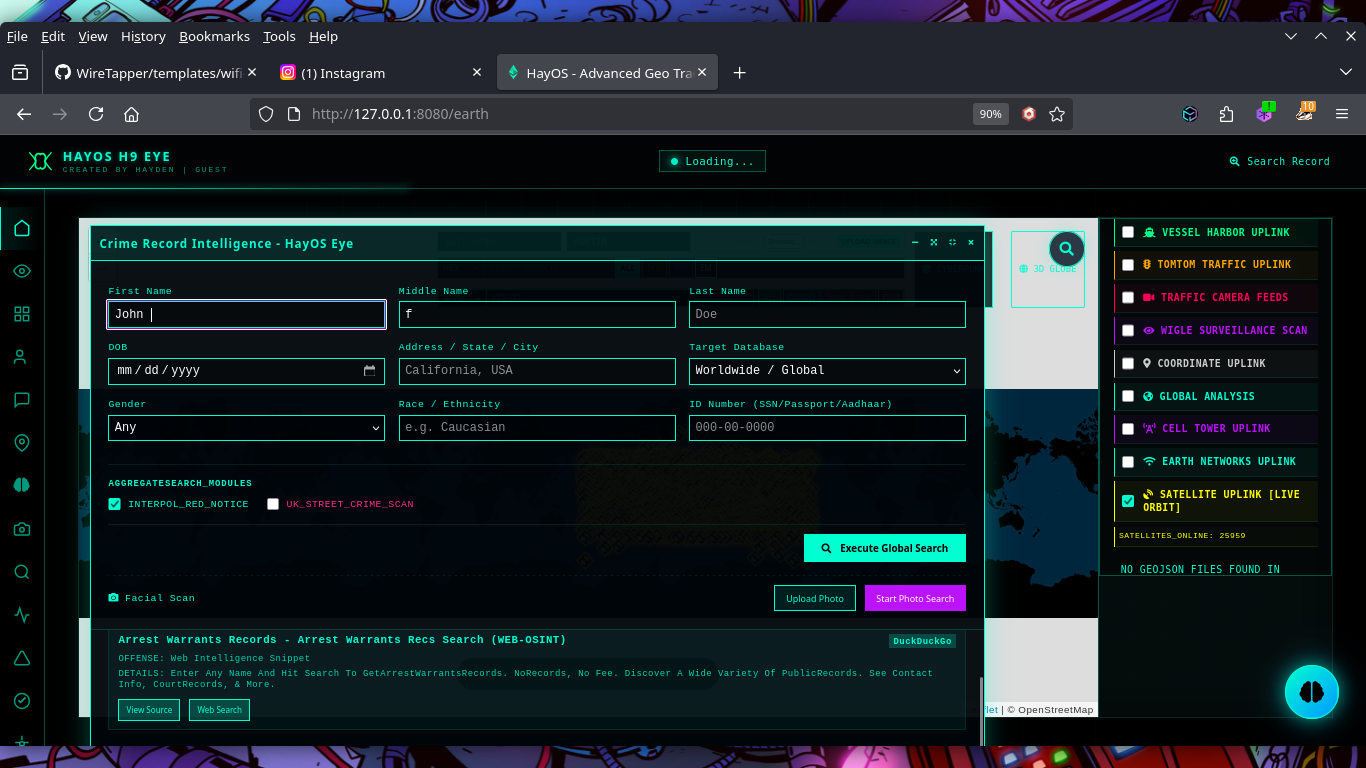
  • 🔎 Criminal Search [IMG] [📖 HOW TO USE GUIDE]
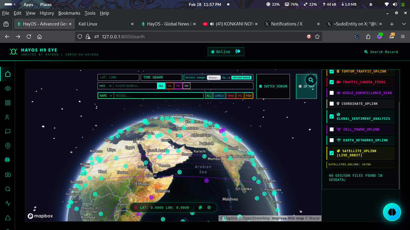
  • 🌍 3D Earth Support [IMG]
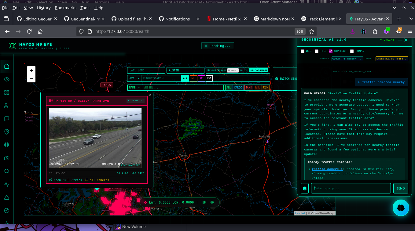
  • 📡 Live CCTV Over Globe (Traffic Camera Feeds) [IMG]
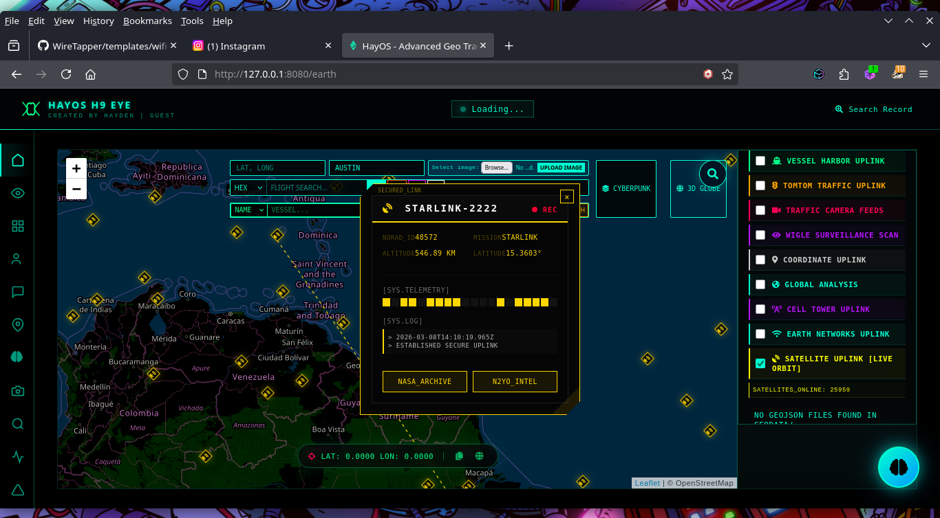
  • 🛰️ Track Satellites [IMG]
  • 📰 Live News Feeds
  • 🚦 Traffic Updates with Live Particle Simulation [IMG]

📚 Documentation

Detailed guides on how to use GeoSentinel's advanced features:

  • 🤖 GeoSential AI Guide - Learn how to use the AI assistant and its commands.
  • 🔍 Search & Dark Web Guide - Instructions for OSINT and dark web searching.

[!Note]

🛰️ SocioSential — Social Media OSINT

GitHub

📡 EthiFi — WiFi Deauther (New Version)

GitHub

🌟 Features

  • 🗺️ Access to GeoJSON data and surveillance grid tiles.
  • ✈️ Real-time flight data.
  • 🚢 Live vessel tracking.
  • 🛰️ Advanced aerial segmentation with YOLO.
  • 🖼️ Image analysis for object and GPS metadata.
  • 📰 Geopolitical news and sentiment analysis.
  • 💹 Market data for commodities and cryptocurrencies.
  • 🌐 Translation services.
  • 🔒 TOR integration for enhanced privacy.
  • 🤖 OLLAMA AI integration for local LLM processing.
  • 🕵️‍♂️ Darkweb Search: Anonymous searching across multiple .onion engines via TOR integration.
  • 🔍 Advanced Web Scraper: Multi-engine OSINT search with Google Dorking for social media platforms (Twitter, Reddit, Instagram, etc.).
  • 🤖 GeoSential AI: Intelligent assistant for automated real-time tracking of flights and vessels with integrated OSINT.

📸 Feature Preview

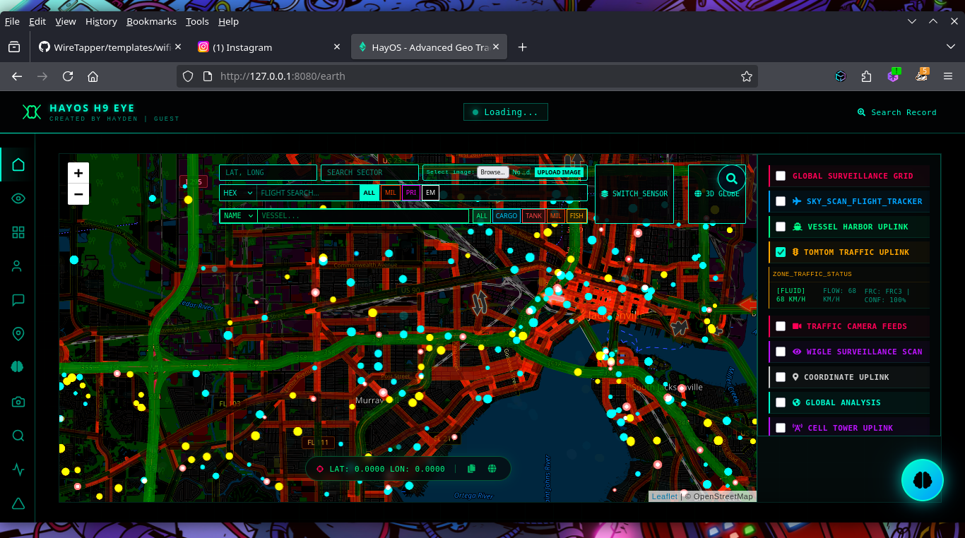
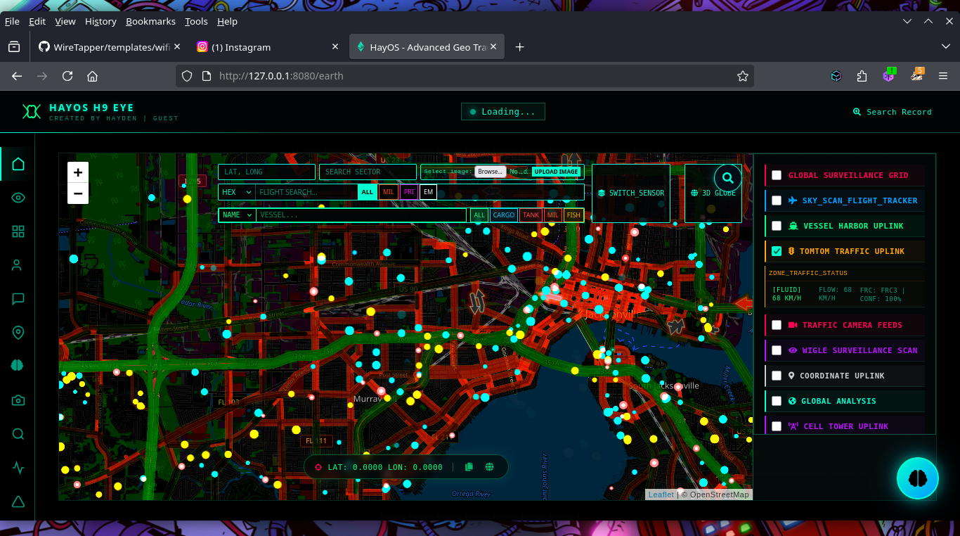
🌍 Earth HTML Features

  • Interactive global map with real-time tracking
  • Advanced search capabilities (HEX, flight, vessel, coordinates)
  • TomTom Maps API integration for detailed mapping
  • Activity logging and user tracking
  • Responsive design for all devices
  • GPS metadata extraction from images
  • Real-time data visualization
  • Integrated GeoSential AI for automated tracking and analysis
  • Advanced web scanning with social media dorking capabilities

📦 Download and Move geodata Folder to Root Directory

🔗 Download Link

👉 Download geodata folder

📝 Configuration

API Keys Required

  • TomTom Maps API: Add your key in templates/earth.html (line ~1850)

    root@kitploit:~
    const tomtomApiKey = 'YOUR_TOMTOM_API_KEY';
    
    • Also in line const tomtomApiKey = ''; (Used for global Map Traffic Layers)
    • Line 2426: const accessToken = ''; (Optional Mapbox Access Token for the 3D globe)
    • Line 2491: const weatherApiKey = ''; (Used for OpenWeatherMap API data inside popups)
    • Line 2501: const tomtomApiKey = ''
    • Line 7021 Mapbox needed
  • Other APIs: Add relevant API keys in app.py api are nned across the file.


🛰️ GeoSentinel Installation Guide

Option 1: Clone directly

root@kitploit:~
git clone https://github.com/h9zdev/GeoSentinel.git

Option 2: Fork the repository

https://github.com/h9zdev/GeoSentinel/fork

Then clone your fork:

root@kitploit:~
git clone https://github.com/<your-username>/GeoSentinel.git

📂 Navigate to Project Directory

root@kitploit:~
cd GeoSentinel

🧩 Install Dependencies

root@kitploit:~
pip install -r requirements.txt

(Optional but recommended)

root@kitploit:~
python -m venv venv
source venv/bin/activate   # Linux / macOS
venv\Scripts\activate      # Windows

▶️ Run the Application

root@kitploit:~
python app.py

🌐 Open in Browser

  • Earth View
    https://127.0.0.1:8000/earth

  • News Dashboard https://127.0.0.1:8000/news

  • WIFI AND BLUETOOTH LOACTER Dashboard https://127.0.0.1:8000/map-w


🔒 TOR Installation & Setup (Linux)

Option 1: Install TOR from Package Manager

root@kitploit:~
# Ubuntu/Debian
sudo apt-get update
sudo apt-get install tor torbrowser-launcher -y

# Fedora/RHEL
sudo dnf install tor torbrowser-launcher -y

Option 2: Install TOR from Source

root@kitploit:~
# Download TOR
cd /tmp
wget https://archive.torproject.org/tor-package-archive/tor-latest.tar.gz
tar -xzf tor-latest.tar.gz
cd tor-*

# Compile and install
./configure
make
sudo make install

Start TOR Service

root@kitploit:~
# Start TOR daemon
sudo systemctl start tor
sudo systemctl enable tor  # Enable on boot

# Or run manually
tor

# Verify TOR is running
curl --socks5 127.0.0.1:9050 https://check.torproject.org/api/ip


🤖 OLLAMA Installation & Setup

Installation Steps

Step 1: Download OLLAMA

root@kitploit:~
# macOS
curl -fsSL https://ollama.ai/install.sh | sh

# Linux
curl -fsSL https://ollama.ai/install.sh | sh

# Or download from
https://ollama.ai/download

Step 2: Verify Installation

root@kitploit:~
ollama --version

Step 3: Pull a Model

root@kitploit:~
# Pull Llama 2 model (7B parameters)
ollama pull llama2

# Or pull other models
ollama pull mistral      # Mistral model
ollama pull neural-chat  # Neural Chat model
ollama pull orca-mini    # Orca Mini model

Step 4: Run OLLAMA Server

root@kitploit:~
# Start OLLAMA server (runs on localhost:11434)
ollama serve

▶️ Watch on YouTube

Watch the video

🔗 Direct link: https://youtu.be/v4IKzEb03u0

🙏 API TO USE

Below is a list of APIs used in GeoSentinel and where to obtain your API keys:

  • 🌍 OpenStreetMap - Geocoding and map data.
  • ✈️ ADSB.one - Real-time flight tracking data.
  • 🚢 AISstream.io - Real-time vessel tracking (AIS).
  • 📊 CoinGecko - Cryptocurrency market data.
  • 📰 NewsAPI - Global news feeds.
  • 🗺️ TomTom Maps - Mapping and routing services.
  • 📶 OpenCellID - Cell tower location data.
  • 🤗 Hugging Face - AI models and inference.
  • 🤖 OpenRouter - Unified AI model gateway.
  • 📡 OpenSky Network - Flight metadata and routing.
  • 🌐 MyMemory Translation - Free translation services.
  • 🐦 Twitter/X API - Social media OSINT.
  • 🔍 DuckDuckGo - Web search integration.
  • 🌐 Google Search - Web search integration.
  • 🅱️ Bing Search - Web search integration.
  • 🔒 Ahmia - Dark web search services.
  • 🦙 Ollama - Local LLM processing.

GeoSentinel Search Crawler Screenshot

GeoSentinel Crawler Search Screenshot

GeoSentinel Monitor Option Screenshot

GeoSentinel Monitor Option Screenshot

Dark Web Search and Monitoring Screenshot

Dark Web Search & Monitoring Screenshot

🗺️ Images of GeoSentinel UI

GeoSentinel Screenshot GeoSentinel Screenshot GeoSentinel Screenshot GeoSentinel Screenshot GeoSentinel Screenshot GeoSentinel Screenshot GeoSentinel Screenshot

📜 License

This project is licensed under the Creative Commons Attribution-NonCommercial 4.0 International (CC BY-NC 4.0) License. See the LICENSE file for more details.

Unauthorized use is strictly prohibited.

📧 Contact: [email protected]

☕ Support

Donate via Monero: 45PU6txuLxtFFcVP95qT2xXdg7eZzPsqFfbtZp5HTjLbPquDAugBKNSh1bJ76qmAWNGMBCKk4R1UCYqXxYwYfP2wTggZNhq

👥 Contributors and Developers

haybnzz
H9yzz
VaradScript
Steiynbrodt

👥

X9 CYBERNETICS

Star History

Star History Chart

If you use NeuroTumorNet in your research, please cite: Made with ❤️ and lots of ☕️.

Download Tool
FeaturePreviewFeaturePreview
🔎 Criminal Search🌍 3D Earth Support
📡 Live CCTV Over Globe🛰️ Track Satellites
🚦 Traffic Updates with Particle Simulation📰 Live News FeedsComing Soon