 cipher387/osint_stuff_tool_collection

Curated collection of 1000+ online OSINT tools and services for geolocation, social media, domain/IP, email, image and archive investigations.
<div align="center">
<h1>Cyber Detective's OSINT tools collection</h1>
<img alt="GitHub stars" src="https://img.shields.io/github/stars/cipher387/osint_stuff_tool_collection">
<img alt="GitHub forks" src="https://img.shields.io/github/forks/cipher387/osint_stuff_tool_collection"> <br>
<br>
<br>
</div>
Hello! On my Twitter account [@cyb_detective](https://linktr.ee/cyb_detective) I post different services, techniques, tricks and notes about OSINT and more. I collect all the links from my tweets in this collection (already 1000+ services for a wide variety of purposes).
Thank you for following me! [@cyb_detective](https://cybdetective.com)
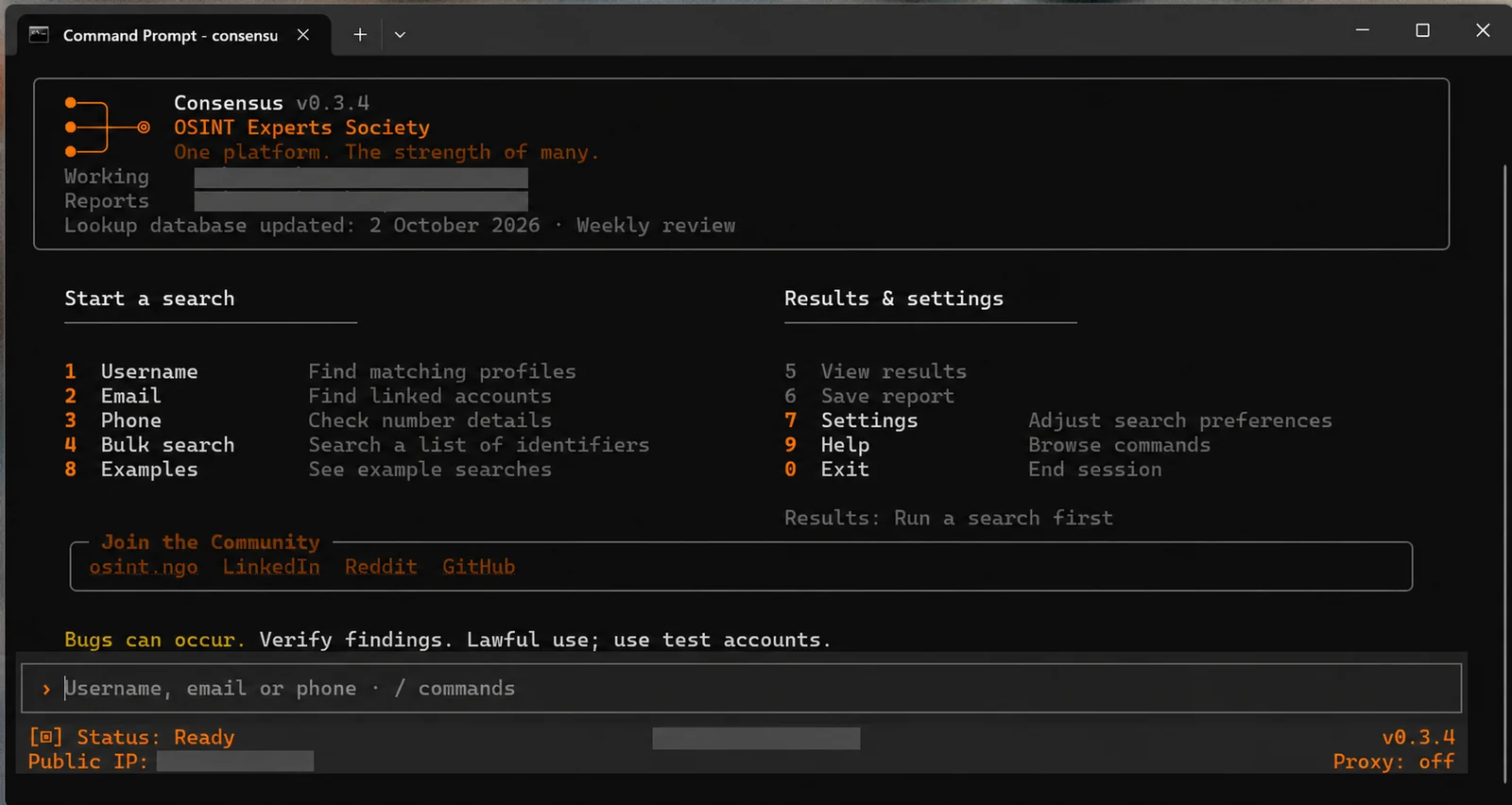
If you need to gather information as quickly as possible using a username, email address or phone number, try starting with Consensus. This command-line tool includes over 7,900 lookup modules from 19 open-source projects.
[Consensus OSINT Github page](https://github.com/OSINT-Experts-Society)
Don't forget that OSINT's main strength is in automation. Read the [Netlas Cookbook](https://github.com/netlas-io/netlas-cookbook) for details and examples.
<i>I have been working on this repository since the summer of 2021. Many tools are constantly becoming obsolete, no longer supported or working at all. But I don't remove from the list so you can use their names and descriptions to find analogues.</i>
## Most important categories
| Section | Link |
|-------------------------------------------|--------------------------------------------------------------------------------------------------------|
| Maps, Geolocation and Transport | [Explore](#maps-geolocation-and-transport) |
| Social Media | [Explore](#social-media) |
| Domain/IP/Links | [Explore](#domainiplinks) |
| Image Search and Identification | [Explore](#image-search-and-identification) |
| Cryptocurrencies | [Explore](#cryptocurrencies) |
| Messengers | [Explore](#messengers) |
| Code | [Explore](#code) |
| Search engines | [Explore](#search-engines) |
| IOT | [Explore](#iot) |
| Archives | [Explore](#archives) |
| Passwords | [Explore](#passwords) |
| Emails | [Explore](#emails) |
| Nicknames | [Explore](#nicknames) |
## [](#table-of-contents) Table of contents
- [Maps, Geolocation and Transport](#maps-geolocation-and-transport)
- [Social media and photos](#social-media-and-photos)
- [Nature](#nature)
- [Aviation](#aviation)
- [Maritime](#maritime)
- [Railway](#railway)
- [Routes](#routes)
- [Politics, conflicts and crisis](#politics-conflicts-and-crisis)
- [Iran vs USA conflict monitoring](#iran-monitoring)
- [Worldwide events monitoring](#worldwide-events-monitoring)
- [Urban and industrial infrastructure](#urban-and-industrial-infrastructure)
- [Culture](#culture)
- [Worldwide street webcams](#worldwide-street-webcams)
- [Tools](#tools)
- [Transport](#transport)
- [Communications, Internet, Technologies](#communications-internet-technologies)
- [Anomalies and Lost Places](#anomalies-and-lost-places)
- [Street View](#street-view)
- [Satellite/aerial imagery](#satelliteaerial-imagery)
- [Military tracking](#military-tracking)
- [Military visalisation](#military-visalisation)
- [Other](#other)
- [Social Media](#social-media)
- [Twitter](#twitter)
- [YouTube](#youtube)
- [TikTok](#tiktok)
- [Protonmail](#protonmail)
- [Facebook](#facebook)
- [Clubhouse](#clubhouse)
- [Linkedin](#linkedin)
- [Xing](#xing)
- [Reddit](#reddit)
- [Onlyfans](#onlyfans)
- [Snapchat](#snapchat)
- [Twitch](#twitch)
- [Fidonet](#fidonet)
- [4chan](#4chan)
- [Usenet](#usenet)
- [Tumblr](#tumblr)
- [Flickr](#flickr)
- [Spotify](#spotify)
- [Discord](#discord)
- [Mastodon](#mastodon)
- [Yandex](#yandex)
- [Instagram](#instagram)
- [Google](#google)
- [Patreon](#patreon)
- [Github](#github)
- [Wikipedia](#wikipedia)
- [Parler](#parler)
- [Pornhub](#pornhub)
- [Steam](#steam)
- [Minecraft](#minecraft)
- [Xbox](#xbox)
- [VK](#vk)
- [Office365](#office365)
- [OneDrive](#onedrive)
- [Udemy](#udemy)
- [Duolingo](#duolingo)
- [Universal](#universal)
- [Downloaders](#downloaders)
- [Messengers](#messengers)
- [Telegram](#telegram)
- [WhatsApp](#whatsapp)
- [Kik](#kik)
- [Slack](#slack)
- [Skype](#skype)
- [Domain/IP/Links](#domainiplinks)
- [Dorks/Pentest/Vulnerabilities](#dorkspentestvulnerabilities)]
- [APK analysis](#apk-analysis)
- [Searchers, scrapers, extractors, parsers](#searchers-scrapers-extractors-parsers)
- [Wordlists generators](#wordlists-generators)
- [Redirect lookup](#redirect-lookup)
- [Cookies analyze](#cookies-analyze)
- [Website's files metadata analyze and files downloads](#websites-files-metadata-analyze-and-files-downloads)
- [Backlinks analyze](#backlinks-analyze)
- [Website analyze](#website-analyze)
- [Favicon search](#favicon-search)
- [Domain/IP investigation](#domainip-investigation)
- [Subdomains scan/brute](#subdomains-scanbrute)
- [Cloudfare](#cloudfare)
- [Databases of domains](#databases-of-domains)
- [Website traffic look up](#website-traffic-look-up)
- [Website technology look up](#website-technology-look-up)
- [Find directories](#find-directories)
- [Source Code Analyzes](#source-code-analyzes)
- [Broken Links Checkers](#broken-links-checkers)
- [URL unshorteners](#url-unshorteners)
- [Text Analyze](#text-analyze)
- [Sound indefication and analyze](#sound-indefication-and-analyze)
- [Sound search and analyze](#sound-search-and-analyze)
- [Video editing and analyze](#video-editing-and-analyze)
- [Image Search and Identification](#image-search-and-identification)
- [Reverse Image Search Engines and automation tools](#reverse-image-search-engines-and-automation-tools)
- [Image editing tools](#image-editing-tools)
- [Other Image Search Engines](#other-image-search-engines)
- [Image Analyze](#image-analyze)
- [Exif Analyze and editing](#exif-analyze-and-editing)
- [Face recognition and search](#face-recognition-and-search)
- [Font Indenfication](#font-indenfication)
- [Cryptocurrencies](#cryptocurrencies)
- [Code](#code)
- [Search engines](#search-engines)
- [Open directories search engines](#open-directories-search)
- [Universal search tools](#universal-search-tools)
- [Darknet/deepweb search tools](#darknetdeepweb-search-tools)
- [Public buckets search tools](#public-buckets-search-tools)
- [Bugbounty/vulnerabilities search tools](#bugbountyvulnerabilities-search-tools)
- [Filesharing Search Engines](#filesharing-search-engines)
- [Tools for DuckDuckGo](#tools-for-duckduckgo)
- [Tools for Google](#tools-for-google)
- [IOT](#iot)
- [Archives](#archives)
- [Tools for working with web archives](#tools-for-working-with-web-archives)
- [Archives of documents/newspapers](#archives-of-documentsnewspapers)
- [Tools for working with WARC (WebARChive) files](#warc)
- [Factchecking](#factchecking)
- [Datasets](#datasets)
- [Science](#science)
- [Passwords](#passwords)
- [Emails](#emails)
- [MBOX files](#mbox)
- [IDs](#ids)
- [Nicknames](#nicknames)
- [Phone numbers](#phone-numbers)
- [Universal Contact Search and Leaks Search](#universal-contact-search-and-leaks-search)
- [Sock Puppets](#sock-puppets)
- [NOOSINT tools](#noosint-tools)
- [Visualization tools](#visualization-tools)
- [Routine/Data Extraction Automation](#routinedata-extraction-automation)
- [Browser analyze](#browser-analyze)
- [Files](#files)
- [IMEI and serial numbers](#imei-and-serial-numbers)
- [NFT](#nft)
- [Keywords, trends, news analytics](#keywords-trends-news-analytics)
- [Apps and programs](#apps-and-programs)
- [Real estate](#real-estate)
- [Company information search](#company-information-search)
- [Bank information search](#bank-information-search)
- [Brand/trademark information search](#brandtrademark-information-search)
- [Tender/shipment information search](#tendershipment-information-search)
- [Amazon](#amazon)
- [Movies](#movies)
- [Netflix](#netflix)
- [TV/Radio](#tvradio)
- [Tools collections/toolkits](#tools-collectionstoolkits)
- [Databases and data analyzes](#databases-and-data-analyzes)
- [Online OS Emulators](#online-os-emulators)
- [Virtual Machines/Linux distributions](#virtual-machineslinux-distributions)
- [My Projects](#my-projects)
[](#maps-geolocation-and-transport)Maps, Geolocation and Transport
### [](#social-media-and-photos)Social media and photos
| Link | Description |
| --- | --- |
| [Apps.skylens.io](https://app.skylens.io/) | Posts with geotags from five social networks at once on one map (Twitter, YouTube, Instagram, Flickr, Vkontakte) |
| [photo-map.ru](http://photo-map.ru/) | search geotagged photos from VK.com |
| [Snapchat map](https://map.snapchat.com/) | |
| [YouTube Geofind](https://mattw.io/youtube-geofind/) | view YouTube geottaged video on map |
| [Flickr Photo Map](https://www.flickr.com/map) | |
| [Flickr Common Map](http://www.whatsthatpicture.com/flickr/commons-map.php) | displays only Flickr photos distributed under a Creative Commons license (250 of the latest for each location) |
| [I know where your cat lives](https://iknowwhereyourcatlives.com/cat/99638e1fe0) | geottaged photo from Instagram with #cat hashtag |
| [Trendsmap.com](https://www.trendsmap.com/map) | Explore most popular #Twitter trends, hashtags and users on the worldmap |
| [Pastvu.com](https://pastvu.com/) | View historical photos taken at a particular location on a map. |
| [BirdHunt](https://birdhunt.co/) | A very simple tool that allows you to select a geolocation/radius and get a list of recent tweets made in that place. |
| [WikiShootMe](https://wikishootme.toolforge.org/) | Worldwide map of geotagged Wikipedia Creative Commons Images. To display more information, log in with your Media Wiki account. |
| [The Painted Planet](https://hicsuntleones.nl/paintedplanet/) | Click on a point on the map to get a list of landscapes by famous artists depicting the area. |
| [COPERNIX](https://copernix.io/) | Worldwide map of geolocated Wikipedia articles. It's possible to enter the name of a locality to see articles about local streets or attractions. |
| [WikiNearby](https://wikinearby.toolforge.org/?lang=en&q=55.333056%2C+27.248889) | Enter geographic coordinates, language, and get a list of Wikipedia articles about streets, towns, stations and other notable places nearby. |
| [Huntel.io](https://www.huntintel.io/) | get a list of links to Facebook/Instagram locations linked to geographic coordinates |
### [](#nature)Nature
| Link | Description |
| --- | --- |
| [Map View NGMDB](https://ngmdb.usgs.gov/mapview/?center=-97,39.6&zoom=4) | map for exploring some geologic maps and articles from the NGMDB (National Geologic Map Database). |
| [WAQI](http://waqi.info) | World's Air Pollution: Real-time Air Quality Index map |
| [GlobalFishingMap](https://globalfishingwatch.org/map/) | click on a point on the map and get the data on the current fishing effort at that location. |
| [ncei.noaa.gov](https://www.ncei.noaa.gov/maps/hazards/) | Natural Hazards Viewer (worldwide) |
| [Lightingmaps](https://www.lightningmaps.org/) | lightning strikes in real time and also data on thunderstorms that ended months or years ago |
| [Light Pollution World Map](https://www.lightpollutionmap.info/) | showing the degree of light pollution in different countries. It's possible to see the data over time (since 2013) |
| [Global Wetlands Map](https://www2.cifor.org/global-wetlands/) | Interactive map of open waters, mangroves, swamps, fens, riverines, floodswamps, marshs, wet meadows and floodplains (unfortunately, there are not all countries in the world) |
| [Fire MAP NASA](https://firms.modaps.eosdis.nasa.gov/map/) | online map of fire hotspots around the world (data from VIIRS and MODIS satellites, last 24 hours) |
| [Ocearch Shark Tracker](https://www.ocearch.org/tracker/) | Click on a shark on the world map and find out its name, size and travel log. |
| [Surging Seas: Risk Zone Map](https://ss2.climatecentral.org/#12/40.7298/-74.0070?show=satellite&projections=0-K14_RCP85-SLR&level=5&unit=feet&pois=hide) | Map of points where there is a risk of significant sea level rise in the event of melting glaciers. |
| [USA Fishermap](https://usa.fishermap.org/depth-map/) | when you click on a freshwater body of water, its detailed map opens, on which the depth at different points is marked |
| [Mindat.org](https://www.mindat.org/countrylist.php) | mineral maps for different countries |
| [Ventusky.com](https://www.ventusky.com/) | collection of weather map (wind, rain, temperature, air pressure, humidity, waves etc) |
| [Wunderground](https://www.wunderground.com/history) | weather history data |
| [Rain Alarm](http://rain-alarm.com) | shows where it is raining on the map. You can enable notification of approaching rain (in the browser and in the mobile app) |
| [Cyclocane](https://cyclocane.com) | click on the hurricane on the map and get detailed information about it |
| [MeteoBlue](https://www.meteoblue.com/) | Weather stats data |
| [Zoom.earth](https://zoom.earth/) | Worldwide map of rains, storms, fires, heats, winds and others natural phenomenas |
| [NGDC Bathymetry map](https://maps.ngdc.noaa.gov/viewers/bathymetry/) | worldwide detailed interactive bathymetry map |
| [Soar.earth](https://soar.earth/) | big collection satellite, drone and ecological maps |
| [Geodesics on the Earth](https://academo.org/demos/geodesics/) | finding the shortest path between two points |
| [Google Earth](https://www.google.com/earth/) | 3D representation of Earth based primarily on satellite imagery |
| [Everymountainintheworld](http://everymountainintheworld.com/) | Map of the world showing the mountains (with absolute and relative altitude and links to Peakbagger, Listsofjohn and Caltopo). |
| [Rivermap](https://rivermap.org/map/#sprache=en) | Online map with the most detailed information on Europe's rivers (mostly central for the time being, but the data is being updated): direction and speed, water temperature, depth, slope angle, etc. |
| [Global Biodiversity Information Facility](https://www.gbif.org/occurrence/map?q=cobra) | Enter the name of an animal, bird or plant to see a map of where it has been spotted. |
| [Natural Hazards Map (worldwide)](https://www.fmglobal.com/research-and-resources/nathaz-toolkit/flood-map) | Enter location and assess the risk of flooding, earthquakes and hail in this place on the map. |
| [River Runner Global](https://river-runner-global.samlearner.com/) | Click on any point on the map and trace the path that a drop of rainwater takes from current location to the world's oceans. |
| [Macrostrat's geologic map system integrates over 290 bedrock geologic maps from around the world into a single, multiscale database (c).](https://macrostrat.org/) | Macrostrat's geologic map system integrates over 290 bedrock geologic maps from around the world into a single, multiscale database (c). |
| [Global Flood Database (and interactive map)](http://global-flood-database.cloudtostreet.ai/) | Detailed statistics on floods over the last 15 years (worldwide): precipitation levels, flooded area, number of people affected, dates, duration in days, etc. |
| [Gaisma](https://www.gaisma.com/en/) | A site for those who verify the location of a photo by the position of the sun. It is very much inferior in functionality to http://timeanddate.com, but its interface is much simpler. |
| [My Ocean Pro](https://data.marine.copernicus.eu/viewer/expert) | An online map tool for exploring seas and oceans, with more than 277 datasets, including temperature, salinity, wave height, sea ice, acidity, and oxygen concentration. |
### [](#aviation)Aviation
| Link | Description |
| --- | --- |
| [Skyvector](https://skyvector.com/) | tool is designed for planning private flights. And you can find an incredible amount of data about the current situation in the sky on it |
| [Flight Connections](https://www.flightconnections.com/) | click on the airport on the map to see the cities from which it's possible fly direct |
| [World Aviation Accident Database 1962-2007](https://www.ntsb.gov/_layouts/ntsb.aviation/index.aspx) | |
| [World Aviation Accident Database 2008-2021](https://data.ntsb.gov/carol-main-public/basic-search) | |
| [Rzjets.net](http://rzjets.net/aircraft/) | user updated online database (census) of civilian jet and turbojet aircraft |
| [Globe.adsbexchange.com](https://globe.adsb.fi/) | tracking flights on a map |
| [Velocity](https://github.com/AndrewCTF/velocity) | self-hosted map of live aircraft (ADS-B) and ships (AIS) from public feeds that records every position to your own disk, so you can rewind what was flying or sailing near a place and time. Free, open source, no API keys |
| [Transtats.bts.gov](https://transtats.bts.gov/ONTIME/) | flight schedules and data on the actual departure/arrival times of flights in the U.S. for more than 30 years (!)) |
| [Legrooms for Google Flights](https://chrome.google.com/webstore/detail/legrooms-for-google-fligh/nhonfddkgankhjilponlbdccpabaaknp/related) | An extension that displays the size of the legroom between the seats next to the flight information. |
| [Flight Status Info](https://flight-status.info/) | - get a list of airports by city name; - view the flight schedule of a particular airport; - view the flight schedule of a particular airline; - getting detailed information about a flight and more |
### [](#maritime)Maritime
| Link | Description |
| --- | --- |
| [Track Trace](https://www.track-trace.com/container) | tracking a shipping container by number |
| [Container Tracking](http://container-tracking.org/) | tracking a shipping container by number |
| [Searates container tracking](https://www.searates.com/container/tracking/) | tracking a shipping container by number |
| [CMA Voyage Finder](https://www.cma-cgm.com/ebusiness/schedules/voyage) | search for voyage details by voyage number or ship name |
| [The Shipping Database](https://theshippingdatabase.com/) | comprehensive archive of the world ships. There is even data for 1820!!!!!!! |
| [Submarinecablemap.com](https://www.submarinecablemap.com/) | submarine communications cables map |
| [Vesselfinder.com](https://www.vesselfinder.com/) | Examine the position of vessels |
| [Submarine Vessels Tracking Map](https://www.marinevesseltraffic.com/submarine-vessels-tracking-map) | |
| [Ports.com](https://ports.com/sea-route/) | online calculation of travel time between two ports (with optimal path). It's possible to select the speed from 5 to 40 knots. Shows a list of the seas through which it passes. |
| [Live Cruise Ship Tracker](https://www.livecruiseshiptracker.com/) | Large catalogue of cruise ship research materials: - map with trackers; - timetables; - webcams on decks and in ports; - elaborate thematic news aggregator |
### [](#railway)Railway
| Link | Description |
| --- | --- |
| [Amtrak Status Maps Archive Database](https://juckins.net/amtrak_status/archive/html/history.php) | find out the train schedule for a station on a particular day that passed many years ago (since 2008) |
| [Europe station maps floor plan](https://www.nsinternational.com/en/stations/station-maps-floor-plan) | |
| [Rasp.yandex.ru/map/trains](https://rasp.yandex.ru/map/trains) | Live map of trains for Russia, Belarus, Ukraine, Kazahstan and Abhazia |
| [Chronotrains](https://chronotrains-eu.vercel.app/) | A terrific weekend travel planning service for Europeans. It shows how far you can go from a certain station in 5 hours by train. |
| [Direkht Ban Guru](https://direkt.bahn.guru/) | Enter the name of the station to see what cities you can get to by train without changing (+ travel time for each city). |
| [Live Train Tracker](https://mobility.portal.geops.io/world.geops.transit?baselayer=world.geops.travic&layers=paerke,strassennamen,haltekanten,haltestellen,pois,world.geops.traviclive&x=810000&y=5900000&z=5.5) | A world map showing real-time train traffic (with route point's exact geographic coordinates) and schedules on the roads of Europe, North and South America and Australia. |
| [Railcabrides](https://railcabrides.com/en/mapsearch) | Click on a point on the railway on the world map (railways are marked in orange or red) to see a list of rail cab videos from that location. With this service you can see many places where Google Street View has not yet reached! |
| [ZugFinder](https://www.zugfinder.net/en/start) | Detailed information on trains, stations and real-time train traffic for European countries |
### [](#routes)Routes
| Link | Description |
| --- | --- |
| [Ride With GPS](https://ridewithgps.com/users) | |
| [Wandermap](http://www.wandermap.net/en/#/z15/55.7522011,37.6156006/terrain) | hiking routes world map |
| [Runmap](http://www.runmap.net/en/?tab=new#/z15/55.7522011,37.6156006/terrain) | running routes world map |
| [Bikemap](https://www.bikemap.net/) | biking route world map |
### [](#politics-conflicts-and-crisis)Politics, conflicts and crisis
| Link | Description |
| --- | --- |
| [Pentagon Pizza Index](https://www.pizzint.watch/) | The Pentagon Pizza Index tracks real-time pizza activity near the Pentagon as an OSINT indicator of military tension. |
| [Global Terriorism Database](https://twitter.com/cyb_detective/status/1578772549919559681) | Info about more than 200,000 terrorist incidents from 1970 to 2020 (worldwide): - dozens of advanced search options; - statistical data for each group of incidents; - many details on each incident, with sources; |
| [Freedomhouse.org](http://freedomhouse.org/explore-the-map) | map of the world that shows the scores of different countries on the following indicators (on a scale of 1 to 100) |
| [Crimemapping.com](https://www.crimemapping.com/) | pick a state, a police agency, and what crimes and where were committed in the territory under its control in the last 24 hours, a week, or a month. |
| [Citizen.com](https://citizen.com/explore) | live map of incidents (mainly shooting) that happened in the last hours in major U.S. cities |
| [MARITIME AWARENESS PROJECT](https://map.nbr.org/interactivemap/) | detailed map of maritime borders of states, economic zones with statistical data on ports and many other objects |
| [Monitor Tracking Civic Space Worldwide Map](https://monitor.civicus.org) | Civicus (@CIVICUSalliance) |
| [Hungermap](https://hungermap.wfp.org) | Worldwide Hunger Map |
| [Native-land.ca](https://native-land.ca/) | click on the point on the map and find out: - what nation this area used to belong to; - what language was once spoken there; - a historical event that resulted in a nation losing their territory. |
| [RiskMap](https://www.riskmap.com/) | |
| [Liveuamap](https://liveuamap.com/) | |
| [ARGUS](https://argus.prototipo.nl) | free, no-login dashboard: live conflict map (ADS-B flights incl. notable military aircraft, ships at chokepoints, NASA FIRMS thermal detections, DeepState frontline, NGA navigational warnings, Ukraine air-raid alerts), 165 news feeds grouped by viewpoint (West/Russia/Ukraine/Middle East/Asia), 46 live video channels, per-situation pages, national terror threat levels |
| [Crisisgroup](https://www.crisisgroup.org/crisiswatch) | |
| [Hate Map](https://www.splcenter.org/hate-map) | |
| [emmeline.carto.com](https://emmeline.carto.com/me) | |
| [Global Conflict Tracker](https://www.cfr.org/global-conflict-tracker/?category=us) | |
| [Acled data crisis map](https://acleddata.com/dashboard/#/dashboard) | |
| [Frontex Migratory Map](https://frontex.europa.eu/we-know/migratory-map/) | click on a country or region to see how many illegal border crossings have been reported there in the last six months. |
| [Safe Airspace](https://safeairspace.net/) | (Conflict Zone & Risk Database) worldwide map showing the countries where flying over may be dangerous; detailed history of incidents and official warnings for each country |
| [Worldwide Detention Centres Map](https://www.globaldetentionproject.org/detention-centres/map-view) | This service will help in investigations related to illegal emigration, human trafficking, missing refugees and tourists. |
| [OppIntell](https://oppintell.com/) | Nonpartisan opposition research software. Organizes public records on 24,000+ U.S. candidates (FEC and state filings, votes, court records, disclosures, statements) into profiles where every claim links to its source. Public profiles are free to browse (paid app). |
| [Lanes](https://lanes.news/) | Compares how each side's press, and third-country press, report the same events in eight conflicts, and labels claims as corroborated, disputed or single-source. Free, no account. |
| [Legistar Council Meetings (Apify)](https://apify.com/publicrecords/legistar-meetings-scraper) | City council meetings, agenda items, votes and attached documents for any city that publishes on Legistar, each with a link back to the official record. Runs on Apify. |
### [](#iran-monitoring)Iran vs USA conflict monitoring
| Link | Description |
| --- | --- |
| [Strike Radar](https://usstrikeradar.com/) | Real-time geopolitical risk monitor tracking USA-Iran tension indicators. Live data from news, aviation, oil prices, Hormuz shipping incidents. |
| [Iran Strike Map](https://iranstrikemap.com/) | Live interactive map tracking 115+ confirmed strikes in the US-Israel-Iran conflict. |
| [USIranMonitor](https://usiranmonitor.com/) | US-IRAN MONITOR helps US and European companies read the daily reality of US‑Iran relations and prepare, lawfully and confidently, for one of the world's largest untapped markets, guided by counsel who knows both sides first-hand: the culture and language, the domestic politics, the legal system, and the political economy that move the market. |
| [Iran Monitor](https://www.iranmonitor.org/) | Track Iran in real-time: news sentiment, X/Twitter feeds, flight radar, prediction markets, and internet connectivity. |
| [IRWatch](https://irwatch.org) | Free live Iran conflict intelligence dashboard with real-time OSINT feed, AI categorization, military mapping, and Hormuz strait monitoring. |
### [](#worldwide-events-monitoring)Worldwide events monitoring
| Link | Description |
| --- | --- |
| [World Monitor](https://www.worldmonitor.app/) | 59 Map layer types, 468 News & OSINT feeds, 815 Attributed providers, 5 Independent alert origins |
| [Monitor the situation](https://monitor-the-situation.com/) | Live world news map and OSINT conflict tracker: source-linked reports, aircraft, ships, GPS interference, internet outages and regional crisis views. |
| [Glint Trade Terminal](https://glint.trade/terminal) | A real-time intelligence terminal for prediction markets. |
| [WorldwatchUK](https://worldwatch.uk/) | Logistic, militaty, economic, disaster, government and environment events monitoring. |
| [NearMe](https://github.com/mcasrom/nearme-osint) | A real-time geographic OSINT aggregator that combines 15 public and official data sources into a single interactive map with severity levels, continuous measurements, and customizable alerts. Spain focused. |
| [Polyglobe](https://www.pizzint.watch/polyglobe/app) | Maps live global events, military installations, and regional hot spots directly onto an interactive 3D globe interface. |
| [WAR ROOM Global Monitor](https://retrosheep.com/global-monitor) | Publicly sourced data, 24/7 real-time monitoring, 6 OSINT data categories, 28 live feeds. Paid. |
### [](#culture)Culture
| Link | Description |
| --- | --- |
| [Taste Atlas](https://www.tasteatlas.com/) | Worldwide online map of national cuisine. There are thousands of dishes typical of countries or regions as a whole, as well as small towns. |
### [](#urban-and-industrial-infrastructure)Urban and industrial infrastructure
| Link | Description |
| --- | --- |
| [Wheelmap.org](https://wheelmap.org) | map shows public places that are accessible and partially accessible to #wheelchair users |
| [Pedestriansfirst](https://pedestriansfirst.itdp.org/) | Evaluate the pedestrian friendliness of streets in different cities. There is a lot of detailed data that will be useful both for choosing a place to live and for a variety of research |
| [World Population Density Map](https://luminocity3d.org/WorldPopDen/) | Very detailed data. It's possible to look at the density not only by country and city, but also by individual metropolitan areas, towns, and villages |
| [Emporis Buildings Map](https://www.emporis.com/buildings/map) | world map showing notable buildings. For each object you can find out the height, number of floors, type, and purpose |
| [Osmbuildings.org](https://osmbuildings.org/) | world map showing notable buildings. For each object you can find out the height, type, and purpose. |
| [Find Food Support](https://findfoodsupport.withgoogle.com/) | find places where you can get free food by address (USA) |
| [Aqicn](https://aqicn.org/map/world/) | Air pollution gauges on the map |
| [Average Gamma Dose Rate Map](https://eea.government.bg/eea/main-site/bg/output/daily/bulletin-en.html) | Shows measurements of environmental radioactivity in the form of gamma dose rate for the last 24 hours. These measurements originate from some 5500 stations in 39 countries |
| [OpenIndoor](https://app.openindoor.io/#17/48.11915/-1.70188) | A world map where you can see how different buildings look from the inside (number of floors, location of stairways, rooms, doors, etc.). The database of the service is not very large yet, but the project is constantly being developed. |
| [Poweroutage](https://poweroutage.com/) | Map with real-time power outage statistics by country and region. |
| [Open Benches](https://openbenches.org/) | Worldwide map of 22,756 memorial benches (added by users). |
| [Sondehub](https://sondehub.org/) | Worldwide map of radiosondes with detailed info (altitude, coordinates, frequency, manufacturer, sonde-type and much more) |
| [The Meddin Bike-sharing World Map](https://bikesharingworldmap.com/) | 8 million+ bikes in one map. There is information about rental stations that have recently closed or suspended their activities. |
| [Rally Maps](https://www.rally-maps.com/map) | A worldwide map showing thousands of race (regular and one-off) locations. It's possinle to find names of winners, routes, dates and other detailed information (historical data from the 1970s is available). |
| [SKYDB](https://www.skydb.net/) | Worldwide database of skyscrapers and tall buildings. |
| [Street Art Cities](https://streetartcities.com/) | Worldwide street artworks online map: 1,443 cities and counting, 51,510 artworks, 100 countries and 260 verified artists |
| [All Text in NYC](http://alltext.nyc) | A text-search service for finding inscriptions on walls in Brooklyn. |
### [](#worldwide-street-webcams)Worldwide street webcams
| Link | Description |
| --- | --- |
| [Surveillance under Surveillance](https://sunders.uber.space/) | World map of surveillance camera locations (mostly Europe and neighbor countries). For some cameras detailed information is given: geo coordinates, type, mount, timestamp etc|
| [Insecam.org](http://www.insecam.org/) | |
| [Earthcam](https://www.earthcam.com/) | |
| [Camstreamer](https://camstreamer.com/live/map) | |
| [Webcamtaxi](https://www.webcamtaxi.com/en/map.html) | |
| [Skyline Webcams](https://www.skylinewebcams.com/webcam.html) | |
---
[Read more](https://github.com/cipher387/osint_stuff_tool_collection)
